Guara geodata
Guara (Mayabeque) is a seat of a third-order administrative division; located in Cuba in America/Havana (GMT-4) time zone. In our database, there are 154 cities with bigger population. Compared to other cities in Cuba, 78.5% of cities are located further ↓South; 76.2% of cities are located further →East and 53% of cities have higher elevation than Guara. Note1


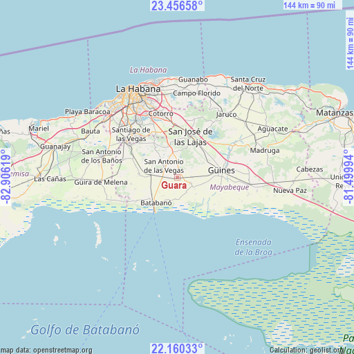
Guara GPS coordinates[2]
22° 48' 36" North, 82° 12' 11.016" West
| Map corner | latitude | longitude |
|---|---|---|
| Upper-left | 23.45658°, | -82.90619° |
| Center: | 22.81°, | -82.20306° |
| Lower-right: | 22.16033°, | -81.49994° |
| Map W x H: | 144.1×144.1 km | = 89.5×89.5mi |
| max Lat: | 23.15917° ⇑21.5% North |
| Guara: | 22.81° |
| min Lat: | ⇓78.5% South 19.90553° |
| min Long | Guara | max Long |
| -84.28599° | -82.20306° | -74.15181° |
| W 23.8%⇐ | ⇒76.2% E |
Elevation
Elevation of Guara is 47 m = 154 ft, and this is 21.6 m = 71 ft below average elevation for this country.
| Max E: |
761 m = 2497 ft | 53% |
| Avg. | 68.6 m = 225 ft | |
| Guara | 47 m = 154 ft | |
Min E: |
3 m = 10 ft | 47% |
See also: Cuba elevation on elevation.city.
Geographical zone
Guara is located in North Torrid zone (between Equator and Tropic of Cancer). Distance of this Northern Tropic circle is 69.7 km =43.3 mi to North.| Distance of | km | miles | from Guara |
|---|---|---|---|
| North Pole | 7470.8 | 4642.1 | to North |
| Arctic Circle | 4864.9 | 3022.9 | to North |
| Tropic Cancer | 69.7 | 43.3 | to North |
| Equator | 2536.2 | 1575.9 | to South |


Nearby cities:
15 places around Guara: (largest is in red/bold)
• Arroyo Naranjo
30.4 km =18.9 mi,  325°
325°
• Batabanó
13.5 km =8.4 mi,  220°
220°
• Bejucal
23.1 km =14.4 mi,  304°
304°
• Boyeros
29.9 km =18.6 mi,  317°
317°
• Güines
18.4 km =11.4 mi,  80°
80°
• Güira de Melena
31.2 km =19.4 mi,  267°
267°
• Jamaica
18.7 km =11.6 mi,  10°
10°
• La Salud
23.6 km =14.7 mi,  286°
286°
• Mañalich
5.7 km =3.5 mi,  88°
88°
• Melena del Sur
5.8 km =3.6 mi,  114°
114°
• Quivicán
15.7 km =9.8 mi,  275°
275°
• San José de las Lajas
17.7 km =11 mi,  17°
17°
• San Miguel del Padrón
30 km =18.6 mi,  341°
341°
• San Nicolás de Bari
29.8 km =18.5 mi,  95°
95°
• Santiago de las Vegas
25.9 km =16.1 mi,  313°
313°
Sources, notices
• [Note1] Compared only with cities in Cuba existing in our database
• [Src1] Map data: © OpenStreetMap contributors (CC-BY-SA)
• [Src2] Other city data from geonames.org with taken over terms of usage.
• [Src3] Geographical zone / Annual Mean Temperature by Robert A. Rohde @ Wikipedia
