Alamar geodata
Alamar (Havana) is a section of populated place; located in Cuba in America/Havana (GMT-4) time zone. With population of 100,000 people, there are 23 cities with bigger population in this country. Compared to other cities in Cuba, 99.4% of cities are located further ↓South; 76.8% of cities are located further →East and 59.1% of cities have higher elevation than Alamar. Note1


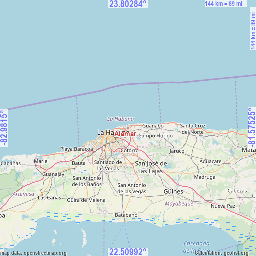
Alamar GPS coordinates[2]
23° 9' 28.584" North, 82° 16' 42.132" West
| Map corner | latitude | longitude |
|---|---|---|
| Upper-left | 23.80284°, | -82.9815° |
| Center: | 23.15794°, | -82.27837° |
| Lower-right: | 22.50992°, | -81.57525° |
| Map W x H: | 143.8×143.8 km | = 89.4×89.4mi |
| max Lat: | 23.15917° ⇑0.6% North |
| Alamar: | 23.15794° |
| min Lat: | ⇓99.4% South 19.90553° |
| min Long | Alamar | max Long |
| -84.28599° | -82.27837° | -74.15181° |
| W 23.2%⇐ | ⇒76.8% E |
Elevation
Elevation of Alamar is 38 m = 125 ft, and this is 30.6 m = 100 ft below average elevation for this country.
| Max E: |
761 m = 2497 ft | 59.1% |
| Avg. | 68.6 m = 225 ft | |
| Alamar | 38 m = 125 ft | |
Min E: |
3 m = 10 ft | 40.9% |
See also: Alamar elevation on elevation.city.
Geographical zone
Alamar is located in North Torrid zone (between Equator and Tropic of Cancer). Distance of this Northern Tropic circle is 31 km =19.3 mi to North.| Distance of | km | miles | from Alamar |
|---|---|---|---|
| North Pole | 7432.1 | 4618.1 | to North |
| Arctic Circle | 4826.3 | 2998.9 | to North |
| Tropic Cancer | 31 | 19.3 | to North |
| Equator | 2574.9 | 1600 | to South |


Nearby cities:
15 places around Alamar: (largest is in red/bold)
• Arroyo Naranjo
16.4 km =10.2 mi,  214°
214°
• Bejucal
27.9 km =17.3 mi,  203°
203°
• Boyeros
21 km =13 mi,  216°
216°
• Centro Habana
9 km =5.6 mi,  256°
256°
• Cerro
11.6 km =7.2 mi,  241°
241°
• Diez de Octubre
11.4 km =7.1 mi,  226°
226°
• Guanabacoa
4.5 km =2.8 mi, 211°
• Habana del Este
5.3 km =3.3 mi,  271°
271°
• Havana
11.1 km =6.9 mi, 255°
• Jamaica
23.2 km =14.4 mi,  151°
151°
• La Habana Vieja
8.2 km =5.1 mi,  248°
248°
• Regla
6.6 km =4.1 mi, 236°
• San José de las Lajas
25.4 km =15.8 mi, 149°
• San Miguel del Padrón
10.3 km =6.4 mi,  189°
189°
• Santiago de las Vegas
23.7 km =14.7 mi, 207°
Sources, notices
• [Note1] Compared only with cities in Cuba existing in our database
• [Src1] Map data: © OpenStreetMap contributors (CC-BY-SA)
• [Src2] Other city data from geonames.org with taken over terms of usage.
• [Src3] Geographical zone / Annual Mean Temperature by Robert A. Rohde @ Wikipedia
