Episkopeió geodata
Episkopeió (Nicosia) is a populated place; located in Cyprus in Asia/Nicosia (GMT+2) time zone. With population of 533 people, there are 110 cities with bigger population in this country. Compared to other cities in Cyprus, 71.8% of cities are located further ↓South; 53% of cities are located further ←West and 82.1% of cities have lower elevation than Episkopeió. Note1


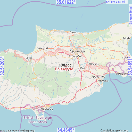
Episkopeió GPS coordinates[2]
35° 2' 33.324" North, 33° 14' 44.808" East
| Map corner | latitude | longitude |
|---|---|---|
| Upper-left | 35.61622°, | 32.54266° |
| Center: | 35.04259°, | 33.24578° |
| Lower-right: | 34.4649°, | 33.94891° |
| Map W x H: | 128×128 km | = 79.5×79.5mi |
| max Lat: | 35.59719° ⇑28.2% North |
| Episkopeió: | 35.04259° |
| min Lat: | ⇓71.8% South 34.66865° |
| min Long | Episkopeió | max Long |
| 32.38166° | 33.24578° | 34.37916° |
| W 53%⇐ | ⇒47% E |
Elevation
Elevation of Episkopeió is 343 m = 1125 ft, and this is 135 m = 443 ft above average elevation for this country.
| Max E: |
1134 m = 3720 ft | 17.9% |
| Episkopeió | 343 m 1125 ft | |
| Avg. | 208 m = 682 ft | |
Min E: |
4 m = 13 ft | 82.1% |
See also: Cyprus elevation on elevation.city.
Geographical zone
Episkopeió is located in North temperate zone (between Tropic of Cancer and the Arctic Circle). Distance of this Northern Tropic circle is 1290.5 km =801.9 mi to South.| Distance of | km | miles | from Episkopeió |
|---|---|---|---|
| North Pole | 6110.7 | 3797 | to North |
| Arctic Circle | 3504.8 | 2177.8 | to North |
| Tropic Cancer | 1290.5 | 801.9 | to South |
| Equator | 3896.4 | 2421.1 | to South |


Nearby cities:
15 places around Episkopeió: (largest is in red/bold)
• Akáki
14.7 km =9.1 mi,  313°
313°
• Alámpra
15.2 km =9.4 mi,  113°
113°
• Aredioú
4.6 km =2.9 mi,  278°
278°
• Ergátes
1.3 km =0.8 mi,  348°
348°
• Klírou
6.7 km =4.2 mi,  247°
247°
• Kokkinotrimithiá
13 km =8.1 mi,  341°
341°
• Káto Defterá
5.4 km =3.4 mi,  29°
29°
• Lythrodóntas
11.2 km =7 mi,  155°
155°
• Mathiátis
12.1 km =7.5 mi,  136°
136°
• Mitseró
11.1 km =6.9 mi,  270°
270°
• Méniko
11.8 km =7.3 mi, 308°
• Psimolofou
2.7 km =1.7 mi, 34°
• Páno Defterá
4.3 km =2.7 mi, 25°
• Péra
1.3 km =0.8 mi, 143°
• Tséri
7.8 km =4.8 mi,  64°
64°
Sources, notices
• [Note1] Compared only with cities in Cyprus existing in our database
• [Src1] Map data: © OpenStreetMap contributors (CC-BY-SA)
• [Src2] Other city data from geonames.org with taken over terms of usage.
• [Src3] Geographical zone / Annual Mean Temperature by Robert A. Rohde @ Wikipedia
