Ergátes geodata
Ergátes (Nicosia) is a populated place; located in Cyprus in Asia/Nicosia (GMT+2) time zone. With population of 1,656 people, there are 58 cities with bigger population in this country. Compared to other cities in Cyprus, 74.4% of cities are located further ↓South; 52.1% of cities are located further ←West and 81.2% of cities have lower elevation than Ergátes. Note1


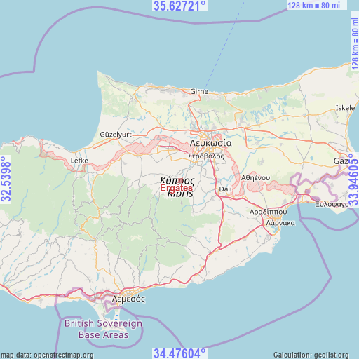
Ergátes GPS coordinates[2]
35° 3' 13.14" North, 33° 14' 34.512" East
| Map corner | latitude | longitude |
|---|---|---|
| Upper-left | 35.62721°, | 32.5398° |
| Center: | 35.05365°, | 33.24292° |
| Lower-right: | 34.47604°, | 33.94605° |
| Map W x H: | 128×128 km | = 79.5×79.5mi |
| max Lat: | 35.59719° ⇑25.6% North |
| Ergátes: | 35.05365° |
| min Lat: | ⇓74.4% South 34.66865° |
| min Long | Ergátes | max Long |
| 32.38166° | 33.24292° | 34.37916° |
| W 52.1%⇐ | ⇒47.9% E |
Elevation
Elevation of Ergátes is 336 m = 1102 ft, and this is 128 m = 420 ft above average elevation for this country.
| Max E: |
1134 m = 3720 ft | 18.8% |
| Ergátes | 336 m 1102 ft | |
| Avg. | 208 m = 682 ft | |
Min E: |
4 m = 13 ft | 81.2% |
See also: Cyprus elevation on elevation.city.
Geographical zone
Ergátes is located in North temperate zone (between Tropic of Cancer and the Arctic Circle). Distance of this Northern Tropic circle is 1291.7 km =802.6 mi to South.| Distance of | km | miles | from Ergátes |
|---|---|---|---|
| North Pole | 6109.5 | 3796.3 | to North |
| Arctic Circle | 3503.6 | 2177 | to North |
| Tropic Cancer | 1291.7 | 802.6 | to South |
| Equator | 3897.6 | 2421.9 | to South |


Nearby cities:
15 places around Ergátes: (largest is in red/bold)
• Akáki
13.7 km =8.5 mi,  310°
310°
• Aredioú
4.3 km =2.7 mi,  262°
262°
• Episkopeió
1.3 km =0.8 mi,  168°
168°
• Klírou
7 km =4.3 mi,  237°
237°
• Kokkinotrimithiá
11.7 km =7.3 mi,  340°
340°
• Káto Defterá
4.6 km =2.9 mi,  40°
40°
• Lythrodóntas
12.5 km =7.8 mi,  156°
156°
• Mathiátis
13.1 km =8.1 mi,  139°
139°
• Mitseró
10.9 km =6.8 mi, 263°
• Mámmari
14.1 km =8.8 mi,  345°
345°
• Méniko
10.9 km =6.8 mi,  304°
304°
• Psimolofou
2 km =1.2 mi,  61°
61°
• Páno Defterá
3.4 km =2.1 mi, 37°
• Péra
2.5 km =1.6 mi, 155°
• Tséri
7.6 km =4.7 mi,  73°
73°
Sources, notices
• [Note1] Compared only with cities in Cyprus existing in our database
• [Src1] Map data: © OpenStreetMap contributors (CC-BY-SA)
• [Src2] Other city data from geonames.org with taken over terms of usage.
• [Src3] Geographical zone / Annual Mean Temperature by Robert A. Rohde @ Wikipedia
