Mathiátis geodata
Mathiátis (Nicosia) is a populated place; located in Cyprus in Asia/Nicosia (GMT+3) time zone. With population of 605 people, there are 103 cities with bigger population in this country. Compared to other cities in Cyprus, 52.1% of cities are located further ↓South; 62.4% of cities are located further ←West and 83.8% of cities have lower elevation than Mathiátis. Note1


Mathiátis GPS coordinates[2]
34° 57' 48.564" North, 33° 20' 10.572" East
| Map corner | latitude | longitude |
|---|---|---|
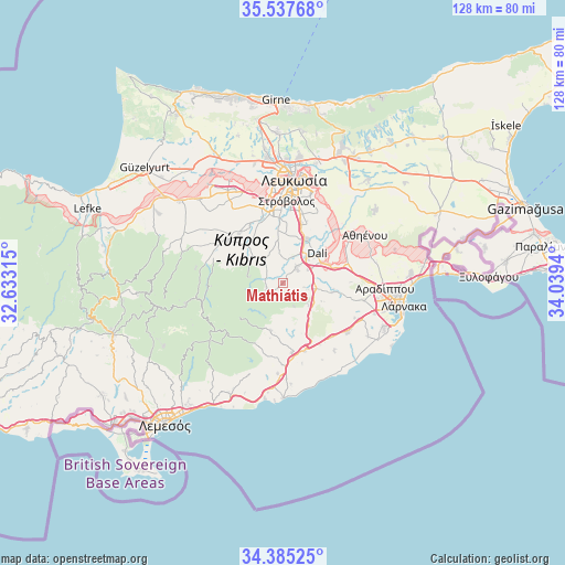
| Upper-left | 35.53768°, | 32.63315° |
| Center: | 34.96349°, | 33.33627° |
| Lower-right: | 34.38525°, | 34.0394° |
| Map W x H: | 128.1×128.1 km | = 79.6×79.6mi |
| max Lat: | 35.59719° ⇑47.9% North |
| Mathiátis: | 34.96349° |
| min Lat: | ⇓52.1% South 34.66865° |
| min Long | Mathiátis | max Long |
| 32.38166° | 33.33627° | 34.37916° |
| W 62.4%⇐ | ⇒37.6% E |
Elevation
Elevation of Mathiátis is 372 m = 1220 ft, and this is 164 m = 538 ft above average elevation for this country.
| Max E: |
1134 m = 3720 ft | 16.2% |
| Mathiátis | 372 m 1220 ft | |
| Avg. | 208 m = 682 ft | |
Min E: |
4 m = 13 ft | 83.8% |
See also: Cyprus elevation on elevation.city.
Geographical zone
Mathiátis is located in North temperate zone (between Tropic of Cancer and the Arctic Circle). Distance of this Northern Tropic circle is 1281.7 km =796.4 mi to South.| Distance of | km | miles | from Mathiátis |
|---|---|---|---|
| North Pole | 6119.5 | 3802.5 | to North |
| Arctic Circle | 3513.6 | 2183.2 | to North |
| Tropic Cancer | 1281.7 | 796.4 | to South |
| Equator | 3887.6 | 2415.6 | to South |


Nearby cities:
15 places around Mathiátis: (largest is in red/bold)
• Alámpra
6.4 km =4 mi,  63°
63°
• Dáli
10.2 km =6.3 mi,  49°
49°
• Episkopeió
12.1 km =7.5 mi,  316°
316°
• Ergátes
13.1 km =8.1 mi, 319°
• Kórnos
7.1 km =4.4 mi,  128°
128°
• Lythrodóntas
3.8 km =2.4 mi,  248°
248°
• Lýmpia
12.1 km =7.5 mi,  71°
71°
• Mosfilotí
8.2 km =5.1 mi,  98°
98°
• Psevdás
11.7 km =7.3 mi, 99°
• Psimolofou
12.9 km =8 mi,  328°
328°
• Páno Defterá
14.2 km =8.8 mi, 333°
• Páno Léfkara
11.1 km =6.9 mi,  193°
193°
• Péra
10.8 km =6.7 mi, 316°
• Siá
5 km =3.1 mi, 100°
• Tséri
12.2 km =7.6 mi,  354°
354°
Sources, notices
• [Note1] Compared only with cities in Cyprus existing in our database
• [Src1] Map data: © OpenStreetMap contributors (CC-BY-SA)
• [Src2] Other city data from geonames.org with taken over terms of usage.
• [Src3] Geographical zone / Annual Mean Temperature by Robert A. Rohde @ Wikipedia
