Chotěboř geodata
Chotěboř (Vysočina) is a populated place; located in Czech Republic in Europe/Prague (GMT+2) time zone. With population of 9,849 people, there are 146 cities with bigger population in this country. Compared to other cities in Czech Republic, 52.3% of cities are located further ↑North; 50.6% of cities are located further →East and 89.4% of cities have lower elevation than Chotěboř. Note1


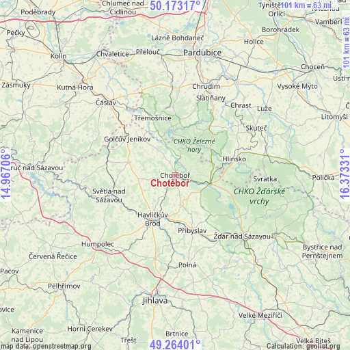
Chotěboř GPS coordinates[2]
49° 43' 14.592" North, 15° 40' 12.648" East
| Map corner | latitude | longitude |
|---|---|---|
| Upper-left | 50.17317°, | 14.96706° |
| Center: | 49.72072°, | 15.67018° |
| Lower-right: | 49.26401°, | 16.37331° |
| Map W x H: | 101.1×101.1 km | = 62.8×62.8mi |
| max Lat: | 51.01104° ⇑52.3% North |
| Chotěboř: | 49.72072° |
| min Lat: | ⇓47.7% South 48.60378° |
| min Long | Chotěboř | max Long |
| 12.17577° | 15.67018° | 18.82683° |
| W 49.4%⇐ | ⇒50.6% E |
Elevation
Elevation of Chotěboř is 525 m = 1722 ft, and this is 173 m = 568 ft above average elevation for this country.
| Max E: |
901 m = 2956 ft | 10.6% |
| Chotěboř | 525 m 1722 ft | |
| Avg. | 352 m = 1155 ft | |
Min E: |
136 m = 446 ft | 89.4% |
See also: Czech Republic elevation on elevation.city.
Geographical zone
Chotěboř is located in North temperate zone (between Tropic of Cancer and the Arctic Circle). Distance of this North polar circle is 1872.7 km =1163.6 mi to North.| Distance of | km | miles | from Chotěboř |
|---|---|---|---|
| North Pole | 4478.6 | 2782.9 | to North |
| Arctic Circle | 1872.7 | 1163.6 | to North |
| Tropic Cancer | 2922.5 | 1816 | to South |
| Equator | 5528.4 | 3435.2 | to South |


Nearby cities:
15 places around Chotěboř: (largest is in red/bold)
• Bojanov
13.6 km =8.5 mi,  10°
10°
• Běstvina
14 km =8.7 mi,  337°
337°
• Habry
13.9 km =8.6 mi,  286°
286°
• Havlíčkova Borová
12.4 km =7.7 mi,  139°
139°
• Křížová
13.6 km =8.5 mi,  105°
105°
• Libice nad Doubravou
3.6 km =2.2 mi,  42°
42°
• Lučice
14.1 km =8.8 mi,  242°
242°
• Maleč
5.7 km =3.5 mi,  4°
4°
• Pohled
13.1 km =8.1 mi,  186°
186°
• Rohozná
14.1 km =8.8 mi,  47°
47°
• Rozsochatec
6 km =3.7 mi,  206°
206°
• Seč
14.1 km =8.8 mi,  355°
355°
• Trhová Kamenice
12.8 km =8 mi, 54°
• Uhelná Příbram
8 km =5 mi,  310°
310°
• Česká Bělá
8.8 km =5.5 mi,  170°
170°
Sources, notices
• [Note1] Compared only with cities in Czech Republic existing in our database
• [Src1] Map data: © OpenStreetMap contributors (CC-BY-SA)
• [Src2] Other city data from geonames.org with taken over terms of usage.
• [Src3] Geographical zone / Annual Mean Temperature by Robert A. Rohde @ Wikipedia
