Horní Planá geodata
Horní Planá (Jihočeský kraj) is a populated place; located in Czech Republic in Europe/Prague (GMT+2) time zone. With population of 2,278 people, there are 566 cities with bigger population in this country. Compared to other cities in Czech Republic, 99.2% of cities are located further ↑North; 83.2% of cities are located further →East and 99.5% of cities have lower elevation than Horní Planá. Note1
Administrative division(s):
- Level 1: Jihočeský kraj
- Level 2: Okres Český Krumlov
- Level 3: Horní Planá


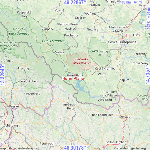
Horní Planá GPS coordinates[2]
48° 46' 2.496" North, 14° 1' 57.252" East
| Map corner | latitude | longitude |
|---|---|---|
| Upper-left | 49.22867°, | 13.32945° |
| Center: | 48.76736°, | 14.03257° |
| Lower-right: | 48.30178°, | 14.7357° |
| Map W x H: | 103.1×103.1 km | = 64.1×64.1mi |
| max Lat: | 51.01104° ⇑99.2% North |
| Horní Planá: | 48.76736° |
| min Lat: | ⇓0.8% South 48.60378° |
| min Long | Horní Planá | max Long |
| 12.17577° | 14.03257° | 18.82683° |
| W 16.8%⇐ | ⇒83.2% E |
Elevation
Elevation of Horní Planá is 774 m = 2539 ft, and this is 422 m = 1385 ft above average elevation for this country.
| Max E: |
901 m = 2956 ft | 0.5% |
| Horní Planá | 774 m 2539 ft | |
| Avg. | 352 m = 1155 ft | |
Min E: |
136 m = 446 ft | 99.5% |
See also: Czech Republic elevation on elevation.city.
Geographical zone
Horní Planá is located in North temperate zone (between Tropic of Cancer and the Arctic Circle). Distance of this North polar circle is 1978.8 km =1229.6 mi to North.| Distance of | km | miles | from Horní Planá |
|---|---|---|---|
| North Pole | 4584.6 | 2848.7 | to North |
| Arctic Circle | 1978.8 | 1229.6 | to North |
| Tropic Cancer | 2816.5 | 1750.1 | to South |
| Equator | 5422.4 | 3369.3 | to South |


Nearby cities:
15 places around Horní Planá: (largest is in red/bold)
• Brloh
22.6 km =14 mi,  36°
36°
• Chvalšiny
16.2 km =10.1 mi,  53°
53°
• Frymburk
15.3 km =9.5 mi,  140°
140°
• Hořice na Šumavě
10.7 km =6.6 mi,  90°
90°
• Ktiš
18.2 km =11.3 mi,  23°
23°
• Kájov
17.2 km =10.7 mi,  73°
73°
• Lenora
24.6 km =15.3 mi,  314°
314°
• Lipno nad Vltavou
20.3 km =12.6 mi,  134°
134°
• Loučovice
23.2 km =14.4 mi, 134°
• Nová Pec
7.8 km =4.8 mi,  276°
276°
• Přídolí
23.4 km =14.5 mi, 86°
• Volary
19 km =11.8 mi,  325°
325°
• Větřní
18.6 km =11.6 mi, 87°
• Černá v Pošumaví
6.6 km =4.1 mi,  119°
119°
• Český Krumlov
21.3 km =13.2 mi,  76°
76°
Sources, notices
• [Note1] Compared only with cities in Czech Republic existing in our database
• [Src1] Map data: © OpenStreetMap contributors (CC-BY-SA)
• [Src2] Other city data from geonames.org with taken over terms of usage.
• [Src3] Geographical zone / Annual Mean Temperature by Robert A. Rohde @ Wikipedia
