Frymburk geodata
Frymburk (Jihočeský kraj) is a populated place; located in Czech Republic in Europe/Prague (GMT+2) time zone. With population of 1,324 people, there are 971 cities with bigger population in this country. Compared to other cities in Czech Republic, 99.8% of cities are located further ↑North; 80.5% of cities are located further →East and 99.2% of cities have lower elevation than Frymburk. Note1


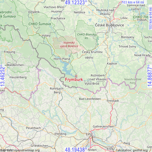
Frymburk GPS coordinates[2]
48° 39' 39.384" North, 14° 9' 56.304" East
| Map corner | latitude | longitude |
|---|---|---|
| Upper-left | 49.12323°, | 13.46252° |
| Center: | 48.66094°, | 14.16564° |
| Lower-right: | 48.19438°, | 14.86877° |
| Map W x H: | 103.3×103.3 km | = 64.2×64.2mi |
| max Lat: | 51.01104° ⇑99.8% North |
| Frymburk: | 48.66094° |
| min Lat: | ⇓0.2% South 48.60378° |
| min Long | Frymburk | max Long |
| 12.17577° | 14.16564° | 18.82683° |
| W 19.5%⇐ | ⇒80.5% E |
Elevation
Elevation of Frymburk is 735 m = 2411 ft, and this is 383 m = 1257 ft above average elevation for this country.
| Max E: |
901 m = 2956 ft | 0.8% |
| Frymburk | 735 m 2411 ft | |
| Avg. | 352 m = 1155 ft | |
Min E: |
136 m = 446 ft | 99.2% |
See also: Czech Republic elevation on elevation.city.
Geographical zone
Frymburk is located in North temperate zone (between Tropic of Cancer and the Arctic Circle). Distance of this North polar circle is 1990.6 km =1236.9 mi to North.| Distance of | km | miles | from Frymburk |
|---|---|---|---|
| North Pole | 4596.5 | 2856.1 | to North |
| Arctic Circle | 1990.6 | 1236.9 | to North |
| Tropic Cancer | 2804.7 | 1742.8 | to South |
| Equator | 5410.6 | 3362 | to South |


Nearby cities:
15 places around Frymburk: (largest is in red/bold)
• Bujanov
19.9 km =12.4 mi,  76°
76°
• Chvalšiny
21.7 km =13.5 mi,  8°
8°
• Dolní Dvořiště
21.1 km =13.1 mi,  91°
91°
• Horní Dvořiště
18.8 km =11.7 mi,  109°
109°
• Horní Planá
15.3 km =9.5 mi,  320°
320°
• Hořice na Šumavě
11.7 km =7.3 mi,  4°
4°
• Kájov
18 km =11.2 mi,  22°
22°
• Lipno nad Vltavou
5.3 km =3.3 mi,  117°
117°
• Loučovice
8.1 km =5 mi, 123°
• Přídolí
19.1 km =11.9 mi,  45°
45°
• Sedlice
20.8 km =12.9 mi, 52°
• Vyšší Brod
11.8 km =7.3 mi, 114°
• Větřní
15.4 km =9.6 mi,  35°
35°
• Černá v Pošumaví
9.5 km =5.9 mi,  334°
334°
• Český Krumlov
20 km =12.4 mi,  33°
33°
Sources, notices
• [Note1] Compared only with cities in Czech Republic existing in our database
• [Src1] Map data: © OpenStreetMap contributors (CC-BY-SA)
• [Src2] Other city data from geonames.org with taken over terms of usage.
• [Src3] Geographical zone / Annual Mean Temperature by Robert A. Rohde @ Wikipedia
