Havířov geodata
Havířov (Moravskoslezský) is a seat of a third-order administrative division; located in Czech Republic in Europe/Prague (GMT+2) time zone. With population of 82,768 people, there are 10 cities with bigger population in this country. Compared to other cities in Czech Republic, 50.8% of cities are located further ↓South; 98.4% of cities are located further ←West and 63.9% of cities have higher elevation than Havířov. Note1


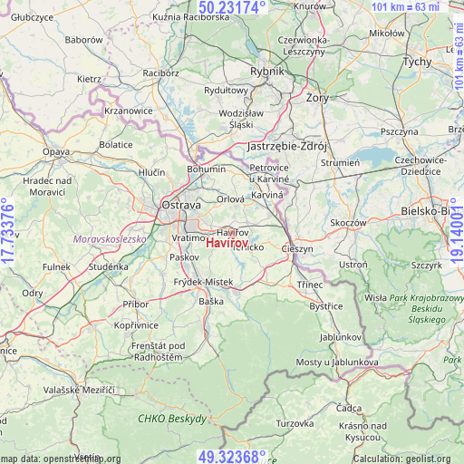
Havířov GPS coordinates[2]
49° 46' 47.424" North, 18° 26' 12.768" East
| Map corner | latitude | longitude |
|---|---|---|
| Upper-left | 50.23174°, | 17.73376° |
| Center: | 49.77984°, | 18.43688° |
| Lower-right: | 49.32368°, | 19.14001° |
| Map W x H: | 101×101 km | = 62.8×62.8mi |
| max Lat: | 51.01104° ⇑49.2% North |
| Havířov: | 49.77984° |
| min Lat: | ⇓50.8% South 48.60378° |
| min Long | Havířov | max Long |
| 12.17577° | 18.43688° | 18.82683° |
| W 98.4%⇐ | ⇒1.6% E |
Elevation
Elevation of Havířov is 278 m = 912 ft, and this is 74 m = 243 ft below average elevation for this country.
| Max E: |
901 m = 2956 ft | 63.9% |
| Avg. | 352 m = 1155 ft | |
| Havířov | 278 m = 912 ft | |
Min E: |
136 m = 446 ft | 36.1% |
See also: Havířov elevation on elevation.city.
Geographical zone
Havířov is located in North temperate zone (between Tropic of Cancer and the Arctic Circle). Distance of this North polar circle is 1866.2 km =1159.6 mi to North.| Distance of | km | miles | from Havířov |
|---|---|---|---|
| North Pole | 4472.1 | 2778.8 | to North |
| Arctic Circle | 1866.2 | 1159.6 | to North |
| Tropic Cancer | 2929.1 | 1820.1 | to South |
| Equator | 5535 | 3439.3 | to South |


Nearby cities:
15 places around Havířov: (largest is in red/bold)
• Albrechtice
6.3 km =3.9 mi,  83°
83°
• Bruzovice
7.3 km =4.5 mi,  195°
195°
• Dolní Domaslavice
8.3 km =5.2 mi,  159°
159°
• Doubrava
9.3 km =5.8 mi,  19°
19°
• Horní Bludovice
3.4 km =2.1 mi,  180°
180°
• Horní Suchá
3.8 km =2.4 mi,  58°
58°
• Horní Těrlicko
4.5 km =2.8 mi,  133°
133°
• Lučina
6.6 km =4.1 mi,  173°
173°
• Orlová
7.3 km =4.5 mi,  356°
356°
• Petřvald
6.6 km =4.1 mi,  329°
329°
• Sedliště
8.4 km =5.2 mi,  215°
215°
• Stonava
7.6 km =4.7 mi, 56°
• Vratimov
9.2 km =5.7 mi,  263°
263°
• Václavovice
5.4 km =3.4 mi,  239°
239°
• Šenov
4.6 km =2.9 mi,  288°
288°
Sources, notices
• [Note1] Compared only with cities in Czech Republic existing in our database
• [Src1] Map data: © OpenStreetMap contributors (CC-BY-SA)
• [Src2] Other city data from geonames.org with taken over terms of usage.
• [Src3] Geographical zone / Annual Mean Temperature by Robert A. Rohde @ Wikipedia
