Stonava geodata
Stonava (Moravskoslezský) is a populated place; located in Czech Republic in Europe/Prague (GMT+2) time zone. With population of 1,771 people, there are 720 cities with bigger population in this country. Compared to other cities in Czech Republic, 52.8% of cities are located further ↓South; 99.1% of cities are located further ←West and 75.4% of cities have higher elevation than Stonava. Note1


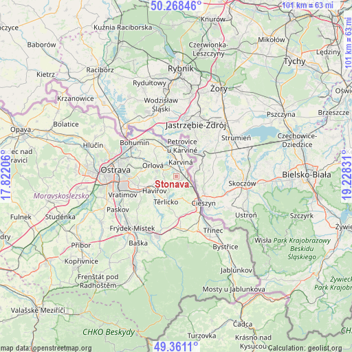
Stonava GPS coordinates[2]
49° 49' 0.876" North, 18° 31' 30.648" East
| Map corner | latitude | longitude |
|---|---|---|
| Upper-left | 50.26846°, | 17.82206° |
| Center: | 49.81691°, | 18.52518° |
| Lower-right: | 49.3611°, | 19.22831° |
| Map W x H: | 100.9×100.9 km | = 62.7×62.7mi |
| max Lat: | 51.01104° ⇑47.2% North |
| Stonava: | 49.81691° |
| min Lat: | ⇓52.8% South 48.60378° |
| min Long | Stonava | max Long |
| 12.17577° | 18.52518° | 18.82683° |
| W 99.1%⇐ | ⇒0.90000000000001% E |
Elevation
Elevation of Stonava is 243 m = 797 ft, and this is 109 m = 358 ft below average elevation for this country.
| Max E: |
901 m = 2956 ft | 75.4% |
| Avg. | 352 m = 1155 ft | |
| Stonava | 243 m = 797 ft | |
Min E: |
136 m = 446 ft | 24.6% |
See also: Czech Republic elevation on elevation.city.
Geographical zone
Stonava is located in North temperate zone (between Tropic of Cancer and the Arctic Circle). Distance of this North polar circle is 1862.1 km =1157.1 mi to North.| Distance of | km | miles | from Stonava |
|---|---|---|---|
| North Pole | 4467.9 | 2776.2 | to North |
| Arctic Circle | 1862.1 | 1157.1 | to North |
| Tropic Cancer | 2933.2 | 1822.6 | to South |
| Equator | 5539.1 | 3441.8 | to South |


Nearby cities:
15 places around Stonava: (largest is in red/bold)
• Albrechtice
3.4 km =2.1 mi,  180°
180°
• Chotěbuz
6.2 km =3.9 mi,  149°
149°
• Dolní Lutyně
11.5 km =7.1 mi,  322°
322°
• Doubrava
5.7 km =3.5 mi,  325°
325°
• Dětmarovice
9.7 km =6 mi, 331°
• Havířov
7.6 km =4.7 mi,  236°
236°
• Horní Bludovice
9.8 km =6.1 mi,  220°
220°
• Horní Suchá
3.8 km =2.4 mi, 235°
• Horní Těrlicko
7.9 km =4.9 mi,  202°
202°
• Karviná
4.3 km =2.7 mi,  16°
16°
• Orlová
7.5 km =4.7 mi,  294°
294°
• Petrovice u Karviné
8.9 km =5.5 mi,  10°
10°
• Petřvald
9.9 km =6.2 mi,  279°
279°
• Český Těšín
10.7 km =6.6 mi,  137°
137°
• Šenov
11 km =6.8 mi,  256°
256°
Sources, notices
• [Note1] Compared only with cities in Czech Republic existing in our database
• [Src1] Map data: © OpenStreetMap contributors (CC-BY-SA)
• [Src2] Other city data from geonames.org with taken over terms of usage.
• [Src3] Geographical zone / Annual Mean Temperature by Robert A. Rohde @ Wikipedia
