Hanušovice geodata
Hanušovice (Olomoucký) is a populated place; located in Czech Republic in Europe/Prague (GMT+2) time zone. With population of 3,556 people, there are 383 cities with bigger population in this country. Compared to other cities in Czech Republic, 70.6% of cities are located further ↓South; 74.1% of cities are located further ←West and 69.7% of cities have lower elevation than Hanušovice. Note1


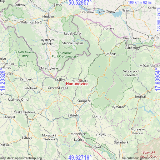
Hanušovice GPS coordinates[2]
50° 4' 49.764" North, 16° 56' 11.076" East
| Map corner | latitude | longitude |
|---|---|---|
| Upper-left | 50.52957°, | 16.23329° |
| Center: | 50.08049°, | 16.93641° |
| Lower-right: | 49.62716°, | 17.63954° |
| Map W x H: | 100.3×100.3 km | = 62.3×62.3mi |
| max Lat: | 51.01104° ⇑29.4% North |
| Hanušovice: | 50.08049° |
| min Lat: | ⇓70.6% South 48.60378° |
| min Long | Hanušovice | max Long |
| 12.17577° | 16.93641° | 18.82683° |
| W 74.1%⇐ | ⇒25.9% E |
Elevation
Elevation of Hanušovice is 414 m = 1358 ft, and this is 62 m = 203 ft above average elevation for this country.
| Max E: |
901 m = 2956 ft | 30.3% |
| Hanušovice | 414 m 1358 ft | |
| Avg. | 352 m = 1155 ft | |
Min E: |
136 m = 446 ft | 69.7% |
See also: Czech Republic elevation on elevation.city.
Geographical zone
Hanušovice is located in North temperate zone (between Tropic of Cancer and the Arctic Circle). Distance of this North polar circle is 1832.7 km =1138.8 mi to North.| Distance of | km | miles | from Hanušovice |
|---|---|---|---|
| North Pole | 4438.6 | 2758 | to North |
| Arctic Circle | 1832.7 | 1138.8 | to North |
| Tropic Cancer | 2962.5 | 1840.8 | to South |
| Equator | 5568.4 | 3460 | to South |


Nearby cities:
15 places around Hanušovice: (largest is in red/bold)
• Bratrušov
8 km =5 mi,  173°
173°
• Dolní Bohdíkov
8.2 km =5.1 mi,  196°
196°
• Králíky
12.6 km =7.8 mi,  271°
271°
• Loučná nad Desnou
11 km =6.8 mi,  93°
93°
• Malá Morava
8 km =5 mi,  282°
282°
• Olšany
14 km =8.7 mi, 203°
• Písařov
12.8 km =8 mi,  228°
228°
• Rapotín
10.3 km =6.4 mi,  138°
138°
• Ruda nad Moravou
11.8 km =7.3 mi, 200°
• Sobotín
13.5 km =8.4 mi,  125°
125°
• Staré Město
9.1 km =5.7 mi,  4°
4°
• Velké Losiny
9.2 km =5.7 mi, 125°
• Vikýřovice
12.6 km =7.8 mi,  154°
154°
• Štěpánov
9.2 km =5.7 mi,  351°
351°
• Šumperk
13 km =8.1 mi, 169°
Sources, notices
• [Note1] Compared only with cities in Czech Republic existing in our database
• [Src1] Map data: © OpenStreetMap contributors (CC-BY-SA)
• [Src2] Other city data from geonames.org with taken over terms of usage.
• [Src3] Geographical zone / Annual Mean Temperature by Robert A. Rohde @ Wikipedia
