Zöschingen geodata
Zöschingen (Bavaria) is a seat of a fourth-order administrative division; located in Germany in Europe/Berlin (GMT+2) time zone. With population of 743 people, there are 8136 cities with bigger population in this country. Compared to other cities in Germany, 86.8% of cities are located further ↑North; 55.9% of cities are located further ←West and 88.3% of cities have lower elevation than Zöschingen. Note1
Administrative division(s):
- Level 1: Bavaria
- Level 2: Swabia
- Level 3: Landkreis Dillingen an der Donau
- Level 4: Zöschingen


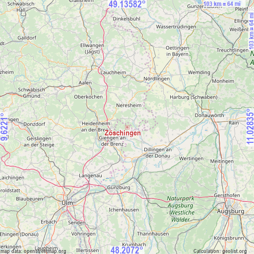
Zöschingen GPS coordinates[2]
48° 40' 25.14" North, 10° 19' 30.792" East
| Map corner | latitude | longitude |
|---|---|---|
| Upper-left | 49.13582°, | 9.6221° |
| Center: | 48.67365°, | 10.32522° |
| Lower-right: | 48.2072°, | 11.02835° |
| Map W x H: | 103.3×103.3 km | = 64.2×64.2mi |
| max Lat: | 55.01917° ⇑86.8% North |
| Zöschingen: | 48.67365° |
| min Lat: | ⇓13.2% South 47.40724° |
| min Long | Zöschingen | max Long |
| 5.92978° | 10.32522° | 14.98853° |
| W 55.9%⇐ | ⇒44.1% E |
Elevation
Elevation of Zöschingen is 496 m = 1627 ft, and this is 246.9 m = 810 ft above average elevation for this country.
| Max E: |
1256 m = 4121 ft | 11.7% |
| Zöschingen | 496 m 1627 ft | |
| Avg. | 249.1 m = 817 ft | |
Min E: |
-5 m = -16 ft | 88.3% |
See also: Germany elevation on elevation.city.
Geographical zone
Zöschingen is located in North temperate zone (between Tropic of Cancer and the Arctic Circle). Distance of this North polar circle is 1989.2 km =1236 mi to North.| Distance of | km | miles | from Zöschingen |
|---|---|---|---|
| North Pole | 4595.1 | 2855.3 | to North |
| Arctic Circle | 1989.2 | 1236 | to North |
| Tropic Cancer | 2806.1 | 1743.6 | to South |
| Equator | 5412 | 3362.9 | to South |


Nearby cities:
15 places around Zöschingen: (largest is in red/bold)
• Amerdingen
13.1 km =8.1 mi,  63°
63°
• Bachhagel
4.6 km =2.9 mi,  184°
184°
• Dischingen
4.2 km =2.6 mi,  46°
46°
• Finningen
12.9 km =8 mi,  99°
99°
• Giengen an der Brenz
8.3 km =5.2 mi,  226°
226°
• Haunsheim
9 km =5.6 mi,  156°
156°
• Heidenheim an der Brenz
12.8 km =8 mi,  272°
272°
• Herbrechtingen
12.4 km =7.7 mi,  242°
242°
• Hermaringen
9.9 km =6.2 mi,  208°
208°
• Medlingen
11.5 km =7.1 mi, 183°
• Mödingen
8.5 km =5.3 mi,  113°
113°
• Nattheim
6.8 km =4.2 mi,  295°
295°
• Neresheim
9.1 km =5.7 mi,  2°
2°
• Wittislingen
9.1 km =5.7 mi,  131°
131°
• Ziertheim
5.9 km =3.7 mi, 113°
Sources, notices
• [Note1] Compared only with cities in Germany existing in our database
• [Src1] Map data: © OpenStreetMap contributors (CC-BY-SA)
• [Src2] Other city data from geonames.org with taken over terms of usage.
• [Src3] Geographical zone / Annual Mean Temperature by Robert A. Rohde @ Wikipedia
