Nattheim geodata
Nattheim (Baden-Württemberg) is a seat of a fourth-order administrative division; located in Germany in Europe/Berlin (GMT+2) time zone. With population of 6,468 people, there are 2316 cities with bigger population in this country. Compared to other cities in Germany, 86.5% of cities are located further ↑North; 54.2% of cities are located further ←West and 93.2% of cities have lower elevation than Nattheim. Note1
Administrative division(s):
- Level 1: Baden-Württemberg
- Level 2: Regierungsbezirk Stuttgart
- Level 3: Landkreis Heidenheim
- Level 4: Nattheim


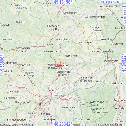
Nattheim GPS coordinates[2]
48° 41' 58.668" North, 10° 14' 31.524" East
| Map corner | latitude | longitude |
|---|---|---|
| Upper-left | 49.16156°, | 9.53896° |
| Center: | 48.69963°, | 10.24209° |
| Lower-right: | 48.23342°, | 10.94522° |
| Map W x H: | 103.2×103.2 km | = 64.1×64.1mi |
| max Lat: | 55.01917° ⇑86.5% North |
| Nattheim: | 48.69963° |
| min Lat: | ⇓13.5% South 47.40724° |
| min Long | Nattheim | max Long |
| 5.92978° | 10.24209° | 14.98853° |
| W 54.2%⇐ | ⇒45.8% E |
Elevation
Elevation of Nattheim is 561 m = 1841 ft, and this is 311.9 m = 1023 ft above average elevation for this country.
| Max E: |
1256 m = 4121 ft | 6.8% |
| Nattheim | 561 m 1841 ft | |
| Avg. | 249.1 m = 817 ft | |
Min E: |
-5 m = -16 ft | 93.2% |
See also: Germany elevation on elevation.city.
Geographical zone
Nattheim is located in North temperate zone (between Tropic of Cancer and the Arctic Circle). Distance of this North polar circle is 1986.3 km =1234.2 mi to North.| Distance of | km | miles | from Nattheim |
|---|---|---|---|
| North Pole | 4592.2 | 2853.5 | to North |
| Arctic Circle | 1986.3 | 1234.2 | to North |
| Tropic Cancer | 2809 | 1745.4 | to South |
| Equator | 5414.9 | 3364.7 | to South |


Nearby cities:
15 places around Nattheim: (largest is in red/bold)
• Bachhagel
9.5 km =5.9 mi,  142°
142°
• Bolheim
10.2 km =6.3 mi,  221°
221°
• Dischingen
9.1 km =5.7 mi,  89°
89°
• Giengen an der Brenz
8.6 km =5.3 mi,  179°
179°
• Haunsheim
14.7 km =9.1 mi, 138°
• Heidenheim an der Brenz
7.1 km =4.4 mi,  250°
250°
• Herbrechtingen
9.9 km =6.2 mi,  209°
209°
• Hermaringen
11.7 km =7.3 mi,  173°
173°
• Königsbronn
10.7 km =6.6 mi,  296°
296°
• Mödingen
15.3 km =9.5 mi,  114°
114°
• Neresheim
8.9 km =5.5 mi,  46°
46°
• Oberkochen
13.7 km =8.5 mi,  312°
312°
• Steinheim am Albuch
13.1 km =8.1 mi,  265°
265°
• Ziertheim
12.6 km =7.8 mi, 114°
• Zöschingen
6.8 km =4.2 mi,  115°
115°
Sources, notices
• [Note1] Compared only with cities in Germany existing in our database
• [Src1] Map data: © OpenStreetMap contributors (CC-BY-SA)
• [Src2] Other city data from geonames.org with taken over terms of usage.
• [Src3] Geographical zone / Annual Mean Temperature by Robert A. Rohde @ Wikipedia
