Zepelin geodata
Zepelin (Mecklenburg-Vorpommern) is a populated place; located in Germany in Europe/Berlin (GMT+1) time zone. With population of 502 people, there are 9363 cities with bigger population in this country. Compared to other cities in Germany, 90.5% of cities are located further ↓South; 82.4% of cities are located further ←West and 94.8% of cities have higher elevation than Zepelin. Note1
Administrative division(s):
- Level 1: Mecklenburg-Vorpommern
- Level 3: Landkreis Rostock
- Level 4: Zepelin


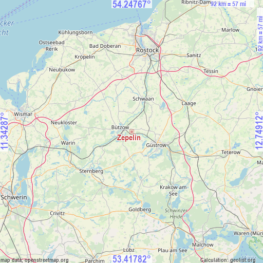
Zepelin GPS coordinates[2]
53° 50' 5.28" North, 12° 2' 45.564" East
| Map corner | latitude | longitude |
|---|---|---|
| Upper-left | 54.24767°, | 11.34287° |
| Center: | 53.8348°, | 12.04599° |
| Lower-right: | 53.41782°, | 12.74912° |
| Map W x H: | 92.3×92.3 km | = 57.4×57.4mi |
| max Lat: | 55.01917° ⇑9.5% North |
| Zepelin: | 53.8348° |
| min Lat: | ⇓90.5% South 47.40724° |
| min Long | Zepelin | max Long |
| 5.92978° | 12.04599° | 14.98853° |
| W 82.4%⇐ | ⇒17.6% E |
Elevation
Elevation of Zepelin is 9 m = 30 ft, and this is 240.1 m = 788 ft below average elevation for this country.
| Max E: |
1256 m = 4121 ft | 94.8% |
| Avg. | 249.1 m = 817 ft | |
| Zepelin | 9 m = 30 ft | |
Min E: |
-5 m = -16 ft | 5.2% |
See also: Germany elevation on elevation.city.
Geographical zone
Zepelin is located in North temperate zone (between Tropic of Cancer and the Arctic Circle). Distance of this North polar circle is 1415.3 km =879.4 mi to North.| Distance of | km | miles | from Zepelin |
|---|---|---|---|
| North Pole | 4021.2 | 2498.7 | to North |
| Arctic Circle | 1415.3 | 879.4 | to North |
| Tropic Cancer | 3379.9 | 2100.2 | to South |
| Equator | 5985.9 | 3719.5 | to South |


Nearby cities:
15 places around Zepelin: (largest is in red/bold)
• Bützow
4.4 km =2.7 mi,  289°
289°
• Gutow
10.2 km =6.3 mi,  144°
144°
• Gülzow
2.2 km =1.4 mi, 138°
• Güstrow
9.3 km =5.8 mi,  116°
116°
• Hohen Sprenz
12.9 km =8 mi,  48°
48°
• Horst
6.3 km =3.9 mi,  326°
326°
• Klein Belitz
12.6 km =7.8 mi,  335°
335°
• Lüssow
6.4 km =4 mi,  86°
86°
• Mistorf
8.5 km =5.3 mi, 49°
• Prüzen
8.9 km =5.5 mi,  185°
185°
• Rühn
7.1 km =4.4 mi,  257°
257°
• Sarmstorf
10.6 km =6.6 mi, 85°
• Schwaan
12.4 km =7.7 mi,  18°
18°
• Tarnow
6.4 km =4 mi,  196°
196°
• Warnow
12.1 km =7.5 mi,  243°
243°
Sources, notices
• [Note1] Compared only with cities in Germany existing in our database
• [Src1] Map data: © OpenStreetMap contributors (CC-BY-SA)
• [Src2] Other city data from geonames.org with taken over terms of usage.
• [Src3] Geographical zone / Annual Mean Temperature by Robert A. Rohde @ Wikipedia
