Rühn geodata
Rühn (Mecklenburg-Vorpommern) is a populated place; located in Germany in Europe/Berlin (GMT+2) time zone. With population of 706 people, there are 8286 cities with bigger population in this country. Compared to other cities in Germany, 90.3% of cities are located further ↓South; 81% of cities are located further ←West and 96.2% of cities have higher elevation than Rühn. Note1
Administrative division(s):
- Level 1: Mecklenburg-Vorpommern
- Level 3: Landkreis Rostock
- Level 4: Rühn


Rühn GPS coordinates[2]
53° 49' 15.6" North, 11° 56' 23.748" East
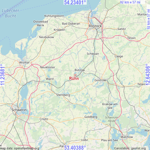
| Map corner | latitude | longitude |
|---|---|---|
| Upper-left | 54.23401°, | 11.23681° |
| Center: | 53.821°, | 11.93993° |
| Lower-right: | 53.40388°, | 12.64306° |
| Map W x H: | 92.3×92.3 km | = 57.4×57.4mi |
| max Lat: | 55.01917° ⇑9.7% North |
| Rühn: | 53.821° |
| min Lat: | ⇓90.3% South 47.40724° |
| min Long | Rühn | max Long |
| 5.92978° | 11.93993° | 14.98853° |
| W 81%⇐ | ⇒19% E |
Elevation
Elevation of Rühn is 6 m = 20 ft, and this is 243.1 m = 798 ft below average elevation for this country.
| Max E: |
1256 m = 4121 ft | 96.2% |
| Avg. | 249.1 m = 817 ft | |
| Rühn | 6 m = 20 ft | |
Min E: |
-5 m = -16 ft | 3.8% |
See also: Germany elevation on elevation.city.
Geographical zone
Rühn is located in North temperate zone (between Tropic of Cancer and the Arctic Circle). Distance of this North polar circle is 1416.8 km =880.4 mi to North.| Distance of | km | miles | from Rühn |
|---|---|---|---|
| North Pole | 4022.7 | 2499.6 | to North |
| Arctic Circle | 1416.8 | 880.4 | to North |
| Tropic Cancer | 3378.4 | 2099.2 | to South |
| Equator | 5984.3 | 3718.5 | to South |


Nearby cities:
15 places around Rühn: (largest is in red/bold)
• Bernitt
9.9 km =6.2 mi,  339°
339°
• Bützow
4.1 km =2.5 mi,  42°
42°
• Gutow
14.5 km =9 mi,  117°
117°
• Gülzow
8.4 km =5.2 mi,  90°
90°
• Horst
7.6 km =4.7 mi,  26°
26°
• Klein Belitz
13.1 km =8.1 mi,  7°
7°
• Lüdersdorf
13.6 km =8.5 mi,  292°
292°
• Lüssow
13.4 km =8.3 mi,  81°
81°
• Mustin
14.1 km =8.8 mi,  171°
171°
• Prüzen
9.6 km =6 mi,  139°
139°
• Sternberg
14.2 km =8.8 mi,  211°
211°
• Tarnow
6.9 km =4.3 mi,  132°
132°
• Warnow
5.5 km =3.4 mi,  224°
224°
• Witzin
11 km =6.8 mi,  186°
186°
• Zepelin
7.1 km =4.4 mi, 77°
Sources, notices
• [Note1] Compared only with cities in Germany existing in our database
• [Src1] Map data: © OpenStreetMap contributors (CC-BY-SA)
• [Src2] Other city data from geonames.org with taken over terms of usage.
• [Src3] Geographical zone / Annual Mean Temperature by Robert A. Rohde @ Wikipedia
