Wörthsee geodata
Wörthsee (Bavaria) is a seat of a fourth-order administrative division; located in Germany in Europe/Berlin (GMT+2) time zone. With population of 4,589 people, there are 2990 cities with bigger population in this country. Compared to other cities in Germany, 94.5% of cities are located further ↑North; 70% of cities are located further ←West and 94.4% of cities have lower elevation than Wörthsee. Note1
Administrative division(s):
- Level 1: Bavaria
- Level 2: Upper Bavaria
- Level 3: Landkreis Starnberg
- Level 4: Wörthsee


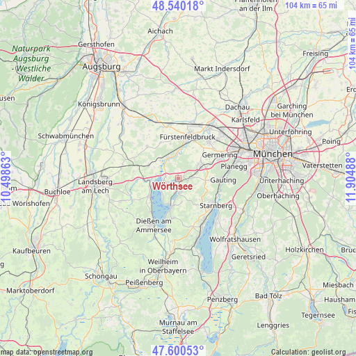
Wörthsee GPS coordinates[2]
48° 4' 21" North, 11° 12' 6.3" East
| Map corner | latitude | longitude |
|---|---|---|
| Upper-left | 48.54018°, | 10.49863° |
| Center: | 48.0725°, | 11.20175° |
| Lower-right: | 47.60053°, | 11.90488° |
| Map W x H: | 104.5×104.5 km | = 64.9×64.9mi |
| max Lat: | 55.01917° ⇑94.5% North |
| Wörthsee: | 48.0725° |
| min Lat: | ⇓5.5% South 47.40724° |
| min Long | Wörthsee | max Long |
| 5.92978° | 11.20175° | 14.98853° |
| W 70%⇐ | ⇒30% E |
Elevation
Elevation of Wörthsee is 585 m = 1919 ft, and this is 335.9 m = 1102 ft above average elevation for this country.
| Max E: |
1256 m = 4121 ft | 5.6% |
| Wörthsee | 585 m 1919 ft | |
| Avg. | 249.1 m = 817 ft | |
Min E: |
-5 m = -16 ft | 94.4% |
See also: Germany elevation on elevation.city.
Geographical zone
Wörthsee is located in North temperate zone (between Tropic of Cancer and the Arctic Circle). Distance of this North polar circle is 2056 km =1277.5 mi to North.| Distance of | km | miles | from Wörthsee |
|---|---|---|---|
| North Pole | 4661.9 | 2896.8 | to North |
| Arctic Circle | 2056 | 1277.5 | to North |
| Tropic Cancer | 2739.2 | 1702.1 | to South |
| Equator | 5345.2 | 3321.4 | to South |


Nearby cities:
15 places around Wörthsee: (largest is in red/bold)
• Alling
10.6 km =6.6 mi,  44°
44°
• Eching
6.6 km =4.1 mi,  277°
277°
• Gilching
7.9 km =4.9 mi,  60°
60°
• Grafrath
5.6 km =3.5 mi,  332°
332°
• Greifenberg
8.8 km =5.5 mi,  268°
268°
• Herrsching am Ammersee
8.4 km =5.2 mi,  192°
192°
• Inning am Ammersee
3.7 km =2.3 mi, 276°
• Kottgeisering
7.1 km =4.4 mi,  314°
314°
• Landsberied
10.8 km =6.7 mi,  346°
346°
• Schondorf am Ammersee
8.5 km =5.3 mi,  255°
255°
• Schöngeising
7.7 km =4.8 mi,  1°
1°
• Seefeld
4.3 km =2.7 mi,  167°
167°
• Türkenfeld
9.5 km =5.9 mi,  292°
292°
• Utting am Ammersee
10 km =6.2 mi,  239°
239°
• Weßling
3.5 km =2.2 mi,  86°
86°
Sources, notices
• [Note1] Compared only with cities in Germany existing in our database
• [Src1] Map data: © OpenStreetMap contributors (CC-BY-SA)
• [Src2] Other city data from geonames.org with taken over terms of usage.
• [Src3] Geographical zone / Annual Mean Temperature by Robert A. Rohde @ Wikipedia
