Landsberied geodata
Landsberied (Bavaria) is a seat of a fourth-order administrative division; located in Germany in Europe/Berlin (GMT+2) time zone. With population of 1,384 people, there are 6107 cities with bigger population in this country. Compared to other cities in Germany, 93.2% of cities are located further ↑North; 69.4% of cities are located further ←West and 92.9% of cities have lower elevation than Landsberied. Note1
Administrative division(s):
- Level 1: Bavaria
- Level 2: Upper Bavaria
- Level 3: Landkreis Fürstenfeldbruck
- Level 4: Landsberied


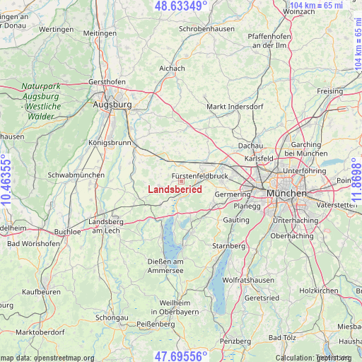
Landsberied GPS coordinates[2]
48° 10' 0.012" North, 11° 10' 0.012" East
| Map corner | latitude | longitude |
|---|---|---|
| Upper-left | 48.63349°, | 10.46355° |
| Center: | 48.16667°, | 11.16667° |
| Lower-right: | 47.69556°, | 11.8698° |
| Map W x H: | 104.3×104.3 km | = 64.8×64.8mi |
| max Lat: | 55.01917° ⇑93.2% North |
| Landsberied: | 48.16667° |
| min Lat: | ⇓6.8% South 47.40724° |
| min Long | Landsberied | max Long |
| 5.92978° | 11.16667° | 14.98853° |
| W 69.4%⇐ | ⇒30.6% E |
Elevation
Elevation of Landsberied is 556 m = 1824 ft, and this is 306.9 m = 1007 ft above average elevation for this country.
| Max E: |
1256 m = 4121 ft | 7.1% |
| Landsberied | 556 m 1824 ft | |
| Avg. | 249.1 m = 817 ft | |
Min E: |
-5 m = -16 ft | 92.9% |
See also: Germany elevation on elevation.city.
Geographical zone
Landsberied is located in North temperate zone (between Tropic of Cancer and the Arctic Circle). Distance of this North polar circle is 2045.5 km =1271 mi to North.| Distance of | km | miles | from Landsberied |
|---|---|---|---|
| North Pole | 4651.4 | 2890.2 | to North |
| Arctic Circle | 2045.5 | 1271 | to North |
| Tropic Cancer | 2749.7 | 1708.6 | to South |
| Equator | 5355.6 | 3327.8 | to South |


Nearby cities:
15 places around Landsberied: (largest is in red/bold)
• Adelshofen
4.1 km =2.5 mi,  296°
296°
• Alling
10.4 km =6.5 mi,  106°
106°
• Emmering
8.8 km =5.5 mi,  77°
77°
• Fürstenfeldbruck
6.7 km =4.2 mi, 78°
• Grafrath
5.6 km =3.5 mi,  180°
180°
• Hattenhofen
7.3 km =4.5 mi,  328°
328°
• Inning am Ammersee
10.1 km =6.3 mi,  186°
186°
• Jesenwang
2.5 km =1.6 mi,  270°
270°
• Kottgeisering
6.1 km =3.8 mi,  203°
203°
• Maisach
9.3 km =5.8 mi,  53°
53°
• Mammendorf
4.6 km =2.9 mi,  356°
356°
• Moorenweis
6.7 km =4.2 mi,  259°
259°
• Oberschweinbach
8 km =5 mi,  354°
354°
• Schöngeising
3.9 km =2.4 mi,  135°
135°
• Türkenfeld
9.2 km =5.7 mi,  222°
222°
Sources, notices
• [Note1] Compared only with cities in Germany existing in our database
• [Src1] Map data: © OpenStreetMap contributors (CC-BY-SA)
• [Src2] Other city data from geonames.org with taken over terms of usage.
• [Src3] Geographical zone / Annual Mean Temperature by Robert A. Rohde @ Wikipedia
