Seefeld geodata
Seefeld (Bavaria) is a seat of a fourth-order administrative division; located in Germany in Europe/Berlin (GMT+2) time zone. With population of 7,033 people, there are 2177 cities with bigger population in this country. Compared to other cities in Germany, 95.1% of cities are located further ↑North; 70.1% of cities are located further ←West and 93.6% of cities have lower elevation than Seefeld. Note1
Administrative division(s):
- Level 1: Bavaria
- Level 2: Upper Bavaria
- Level 3: Landkreis Starnberg
- Level 4: Seefeld


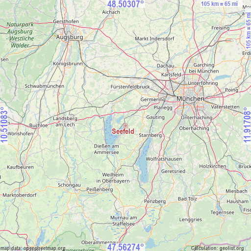
Seefeld GPS coordinates[2]
48° 2' 6.18" North, 11° 12' 50.22" East
| Map corner | latitude | longitude |
|---|---|---|
| Upper-left | 48.50307°, | 10.51083° |
| Center: | 48.03505°, | 11.21395° |
| Lower-right: | 47.56274°, | 11.91708° |
| Map W x H: | 104.6×104.6 km | = 65×65mi |
| max Lat: | 55.01917° ⇑95.1% North |
| Seefeld: | 48.03505° |
| min Lat: | ⇓4.9% South 47.40724° |
| min Long | Seefeld | max Long |
| 5.92978° | 11.21395° | 14.98853° |
| W 70.1%⇐ | ⇒29.9% E |
Elevation
Elevation of Seefeld is 568 m = 1864 ft, and this is 318.9 m = 1046 ft above average elevation for this country.
| Max E: |
1256 m = 4121 ft | 6.4% |
| Seefeld | 568 m 1864 ft | |
| Avg. | 249.1 m = 817 ft | |
Min E: |
-5 m = -16 ft | 93.6% |
See also: Germany elevation on elevation.city.
Geographical zone
Seefeld is located in North temperate zone (between Tropic of Cancer and the Arctic Circle). Distance of this North polar circle is 2060.2 km =1280.1 mi to North.| Distance of | km | miles | from Seefeld |
|---|---|---|---|
| North Pole | 4666.1 | 2899.4 | to North |
| Arctic Circle | 2060.2 | 1280.1 | to North |
| Tropic Cancer | 2735.1 | 1699.5 | to South |
| Equator | 5341 | 3318.7 | to South |


Nearby cities:
15 places around Seefeld: (largest is in red/bold)
• Andechs
7.1 km =4.4 mi,  199°
199°
• Eching
9 km =5.6 mi,  303°
303°
• Feldafing
11.5 km =7.1 mi,  149°
149°
• Gilching
10 km =6.2 mi,  36°
36°
• Grafrath
9.7 km =6 mi,  338°
338°
• Greifenberg
10.5 km =6.5 mi,  292°
292°
• Herrsching am Ammersee
4.9 km =3 mi,  214°
214°
• Inning am Ammersee
6.5 km =4 mi,  315°
315°
• Kottgeisering
10.9 km =6.8 mi,  326°
326°
• Pöcking
9.9 km =6.2 mi,  139°
139°
• Schondorf am Ammersee
9.3 km =5.8 mi,  282°
282°
• Starnberg
10.4 km =6.5 mi,  110°
110°
• Utting am Ammersee
9.6 km =6 mi,  264°
264°
• Weßling
5.1 km =3.2 mi,  30°
30°
• Wörthsee
4.3 km =2.7 mi,  347°
347°
Sources, notices
• [Note1] Compared only with cities in Germany existing in our database
• [Src1] Map data: © OpenStreetMap contributors (CC-BY-SA)
• [Src2] Other city data from geonames.org with taken over terms of usage.
• [Src3] Geographical zone / Annual Mean Temperature by Robert A. Rohde @ Wikipedia
