Wörrstadt geodata
Wörrstadt (Rheinland-Pfalz) is a seat of a fourth-order administrative division; located in Germany in Europe/Berlin (GMT+2) time zone. With population of 7,668 people, there are 2020 cities with bigger population in this country. Compared to other cities in Germany, 67.8% of cities are located further ↑North; 75.1% of cities are located further →East and 52.4% of cities have higher elevation than Wörrstadt. Note1
Administrative division(s):
- Level 1: Rheinland-Pfalz
- Level 3: Landkreis Alzey-Worms
- Level 4: Wörrstadt


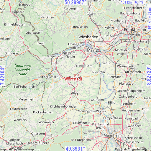
Wörrstadt GPS coordinates[2]
49° 50' 54.996" North, 8° 7' 27.012" East
| Map corner | latitude | longitude |
|---|---|---|
| Upper-left | 50.29987°, | 7.42104° |
| Center: | 49.84861°, | 8.12417° |
| Lower-right: | 49.3931°, | 8.82729° |
| Map W x H: | 100.8×100.8 km | = 62.6×62.6mi |
| max Lat: | 55.01917° ⇑67.8% North |
| Wörrstadt: | 49.84861° |
| min Lat: | ⇓32.2% South 47.40724° |
| min Long | Wörrstadt | max Long |
| 5.92978° | 8.12417° | 14.98853° |
| W 24.9%⇐ | ⇒75.1% E |
Elevation
Elevation of Wörrstadt is 208 m = 682 ft, and this is 41.1 m = 135 ft below average elevation for this country.
| Max E: |
1256 m = 4121 ft | 52.4% |
| Avg. | 249.1 m = 817 ft | |
| Wörrstadt | 208 m = 682 ft | |
Min E: |
-5 m = -16 ft | 47.6% |
See also: Germany elevation on elevation.city.
Geographical zone
Wörrstadt is located in North temperate zone (between Tropic of Cancer and the Arctic Circle). Distance of this North polar circle is 1858.5 km =1154.8 mi to North.| Distance of | km | miles | from Wörrstadt |
|---|---|---|---|
| North Pole | 4464.4 | 2774 | to North |
| Arctic Circle | 1858.5 | 1154.8 | to North |
| Tropic Cancer | 2936.7 | 1824.8 | to South |
| Equator | 5542.6 | 3444 | to South |


Nearby cities:
15 places around Wörrstadt: (largest is in red/bold)
• Armsheim
6.5 km =4 mi,  228°
228°
• Ensheim
4.7 km =2.9 mi,  187°
187°
• Gabsheim
4.4 km =2.7 mi,  121°
121°
• Gau-Weinheim
5.5 km =3.4 mi,  267°
267°
• Jugenheim
5.7 km =3.5 mi,  330°
330°
• Ober-Saulheim
1.9 km =1.2 mi,  25°
25°
• Partenheim
4.9 km =3 mi,  322°
322°
• Schornsheim
3.7 km =2.3 mi,  94°
94°
• Spiesheim
4.3 km =2.7 mi,  176°
176°
• Sulzheim
2.4 km =1.5 mi,  255°
255°
• Sörgenloch
6.7 km =4.2 mi,  55°
55°
• Udenheim
3.8 km =2.4 mi, 62°
• Vendersheim
4.4 km =2.7 mi,  296°
296°
• Wallertheim
5.4 km =3.4 mi,  254°
254°
• Wolfsheim
6.6 km =4.1 mi,  293°
293°
Sources, notices
• [Note1] Compared only with cities in Germany existing in our database
• [Src1] Map data: © OpenStreetMap contributors (CC-BY-SA)
• [Src2] Other city data from geonames.org with taken over terms of usage.
• [Src3] Geographical zone / Annual Mean Temperature by Robert A. Rohde @ Wikipedia
