Udenheim geodata
Udenheim (Rheinland-Pfalz) is a seat of a fourth-order administrative division; located in Germany in Europe/Berlin (GMT+2) time zone. With population of 1,327 people, there are 6228 cities with bigger population in this country. Compared to other cities in Germany, 67.5% of cities are located further ↑North; 74.5% of cities are located further →East and 59.8% of cities have higher elevation than Udenheim. Note1
Administrative division(s):
- Level 1: Rheinland-Pfalz
- Level 3: Landkreis Alzey-Worms
- Level 4: Udenheim


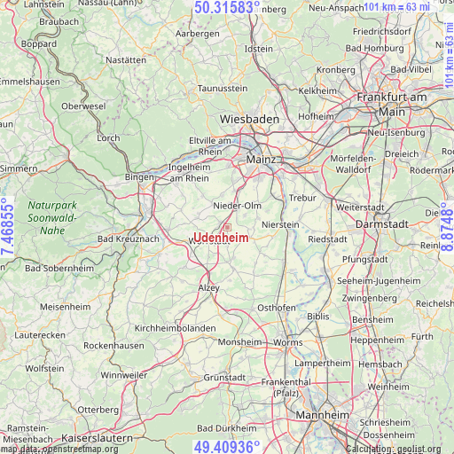
Udenheim GPS coordinates[2]
49° 51' 52.992" North, 8° 10' 18.012" East
| Map corner | latitude | longitude |
|---|---|---|
| Upper-left | 50.31583°, | 7.46855° |
| Center: | 49.86472°, | 8.17167° |
| Lower-right: | 49.40936°, | 8.8748° |
| Map W x H: | 100.8×100.8 km | = 62.6×62.6mi |
| max Lat: | 55.01917° ⇑67.5% North |
| Udenheim: | 49.86472° |
| min Lat: | ⇓32.5% South 47.40724° |
| min Long | Udenheim | max Long |
| 5.92978° | 8.17167° | 14.98853° |
| W 25.5%⇐ | ⇒74.5% E |
Elevation
Elevation of Udenheim is 154 m = 505 ft, and this is 95.1 m = 312 ft below average elevation for this country.
| Max E: |
1256 m = 4121 ft | 59.8% |
| Avg. | 249.1 m = 817 ft | |
| Udenheim | 154 m = 505 ft | |
Min E: |
-5 m = -16 ft | 40.2% |
See also: Germany elevation on elevation.city.
Geographical zone
Udenheim is located in North temperate zone (between Tropic of Cancer and the Arctic Circle). Distance of this North polar circle is 1856.7 km =1153.7 mi to North.| Distance of | km | miles | from Udenheim |
|---|---|---|---|
| North Pole | 4462.6 | 2772.9 | to North |
| Arctic Circle | 1856.7 | 1153.7 | to North |
| Tropic Cancer | 2938.5 | 1825.9 | to South |
| Equator | 5544.4 | 3445.1 | to South |


Nearby cities:
15 places around Udenheim: (largest is in red/bold)
• Gabsheim
4.1 km =2.5 mi,  175°
175°
• Hahnheim
4.7 km =2.9 mi,  95°
95°
• Köngernheim
5.8 km =3.6 mi,  111°
111°
• Nieder-Olm
5.7 km =3.5 mi,  24°
24°
• Ober-Saulheim
2.6 km =1.6 mi,  267°
267°
• Partenheim
6.8 km =4.2 mi,  288°
288°
• Schornsheim
2.1 km =1.3 mi,  173°
173°
• Selzen
6 km =3.7 mi,  94°
94°
• Spiesheim
6.8 km =4.2 mi,  207°
207°
• Stadecken-Elsheim
6.2 km =3.9 mi,  327°
327°
• Sulzheim
6.2 km =3.9 mi,  247°
247°
• Sörgenloch
2.9 km =1.8 mi,  45°
45°
• Undenheim
4.5 km =2.8 mi,  131°
131°
• Wörrstadt
3.8 km =2.4 mi,  242°
242°
• Zornheim
4.7 km =2.9 mi, 53°
Sources, notices
• [Note1] Compared only with cities in Germany existing in our database
• [Src1] Map data: © OpenStreetMap contributors (CC-BY-SA)
• [Src2] Other city data from geonames.org with taken over terms of usage.
• [Src3] Geographical zone / Annual Mean Temperature by Robert A. Rohde @ Wikipedia
