Worpswede geodata
Worpswede (Lower Saxony) is a seat of a fourth-order administrative division; located in Germany in Europe/Berlin (GMT+2) time zone. With population of 9,417 people, there are 1716 cities with bigger population in this country. Compared to other cities in Germany, 83% of cities are located further ↓South; 66.3% of cities are located further →East and 89.7% of cities have higher elevation than Worpswede. Note1


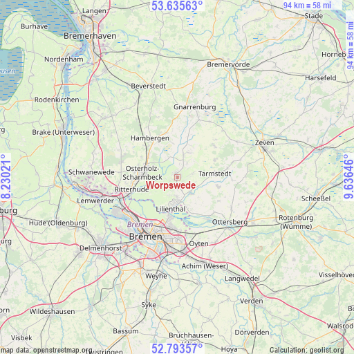
Worpswede GPS coordinates[2]
53° 13' 0.012" North, 8° 55' 59.988" East
| Map corner | latitude | longitude |
|---|---|---|
| Upper-left | 53.63563°, | 8.23021° |
| Center: | 53.21667°, | 8.93333° |
| Lower-right: | 52.79357°, | 9.63646° |
| Map W x H: | 93.6×93.6 km | = 58.2×58.2mi |
| max Lat: | 55.01917° ⇑17% North |
| Worpswede: | 53.21667° |
| min Lat: | ⇓83% South 47.40724° |
| min Long | Worpswede | max Long |
| 5.92978° | 8.93333° | 14.98853° |
| W 33.7%⇐ | ⇒66.3% E |
Elevation
Elevation of Worpswede is 22 m = 72 ft, and this is 227.1 m = 745 ft below average elevation for this country.
| Max E: |
1256 m = 4121 ft | 89.7% |
| Avg. | 249.1 m = 817 ft | |
| Worpswede | 22 m = 72 ft | |
Min E: |
-5 m = -16 ft | 10.3% |
See also: Germany elevation on elevation.city.
Geographical zone
Worpswede is located in North temperate zone (between Tropic of Cancer and the Arctic Circle). Distance of this North polar circle is 1484 km =922.1 mi to North.| Distance of | km | miles | from Worpswede |
|---|---|---|---|
| North Pole | 4089.9 | 2541.3 | to North |
| Arctic Circle | 1484 | 922.1 | to North |
| Tropic Cancer | 3311.2 | 2057.5 | to South |
| Equator | 5917.1 | 3676.7 | to South |


Nearby cities:
15 places around Worpswede: (largest is in red/bold)
• Breddorf
12.9 km =8 mi,  49°
49°
• Grasberg
5 km =3.1 mi,  138°
138°
• Hambergen
12.5 km =7.8 mi,  324°
324°
• Hepstedt
10.9 km =6.8 mi,  64°
64°
• Kirchtimke
14.9 km =9.3 mi,  75°
75°
• Lilienthal
8.5 km =5.3 mi,  193°
193°
• Lübberstedt
15.7 km =9.8 mi,  325°
325°
• Osterholz-Scharmbeck
9.3 km =5.8 mi,  277°
277°
• Rhade
17.3 km =10.7 mi,  43°
43°
• Ritterhude
13.7 km =8.5 mi,  254°
254°
• Tarmstedt
9.7 km =6 mi, 84°
• Vollersode
13 km =8.1 mi,  355°
355°
• Vorwerk
14.9 km =9.3 mi,  104°
104°
• Westertimke
13.3 km =8.3 mi, 80°
• Wilstedt
11.1 km =6.9 mi, 102°
Sources, notices
• [Note1] Compared only with cities in Germany existing in our database
• [Src1] Map data: © OpenStreetMap contributors (CC-BY-SA)
• [Src2] Other city data from geonames.org with taken over terms of usage.
• [Src3] Geographical zone / Annual Mean Temperature by Robert A. Rohde @ Wikipedia
