Rhade geodata
Rhade (Lower Saxony) is a seat of a fourth-order administrative division; located in Germany in Europe/Berlin (GMT+2) time zone. With population of 1,101 people, there are 6845 cities with bigger population in this country. Compared to other cities in Germany, 83.9% of cities are located further ↓South; 63.8% of cities are located further →East and 91.2% of cities have higher elevation than Rhade. Note1


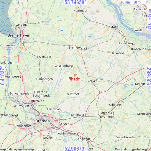
Rhade GPS coordinates[2]
53° 19' 43.392" North, 9° 6' 48.6" East
| Map corner | latitude | longitude |
|---|---|---|
| Upper-left | 53.74658°, | 8.41037° |
| Center: | 53.32872°, | 9.1135° |
| Lower-right: | 52.90673°, | 9.81662° |
| Map W x H: | 93.4×93.4 km | = 58×58mi |
| max Lat: | 55.01917° ⇑16.1% North |
| Rhade: | 53.32872° |
| min Lat: | ⇓83.9% South 47.40724° |
| min Long | Rhade | max Long |
| 5.92978° | 9.1135° | 14.98853° |
| W 36.2%⇐ | ⇒63.8% E |
Elevation
Elevation of Rhade is 18 m = 59 ft, and this is 231.1 m = 758 ft below average elevation for this country.
| Max E: |
1256 m = 4121 ft | 91.2% |
| Avg. | 249.1 m = 817 ft | |
| Rhade | 18 m = 59 ft | |
Min E: |
-5 m = -16 ft | 8.8% |
See also: Germany elevation on elevation.city.
Geographical zone
Rhade is located in North temperate zone (between Tropic of Cancer and the Arctic Circle). Distance of this North polar circle is 1471.6 km =914.4 mi to North.| Distance of | km | miles | from Rhade |
|---|---|---|---|
| North Pole | 4077.5 | 2533.6 | to North |
| Arctic Circle | 1471.6 | 914.4 | to North |
| Tropic Cancer | 3323.7 | 2065.3 | to South |
| Equator | 5929.6 | 3684.5 | to South |


Nearby cities:
15 places around Rhade: (largest is in red/bold)
• Anderlingen
13.6 km =8.5 mi,  68°
68°
• Breddorf
4.6 km =2.9 mi,  208°
208°
• Deinstedt
12.6 km =7.8 mi,  39°
39°
• Gnarrenburg
9.7 km =6 mi,  308°
308°
• Heeslingen
14.7 km =9.1 mi,  95°
95°
• Hepstedt
8.1 km =5 mi,  195°
195°
• Kirchtimke
9.1 km =5.7 mi,  164°
164°
• Ostereistedt
4.8 km =3 mi,  132°
132°
• Sandbostel
9 km =5.6 mi,  6°
6°
• Seedorf
8.3 km =5.2 mi, 73°
• Selsingen
8.3 km =5.2 mi,  53°
53°
• Tarmstedt
11.8 km =7.3 mi,  191°
191°
• Vollersode
13.1 km =8.1 mi,  272°
272°
• Westertimke
10.3 km =6.4 mi,  173°
173°
• Zeven
11.4 km =7.1 mi,  108°
108°
Sources, notices
• [Note1] Compared only with cities in Germany existing in our database
• [Src1] Map data: © OpenStreetMap contributors (CC-BY-SA)
• [Src2] Other city data from geonames.org with taken over terms of usage.
• [Src3] Geographical zone / Annual Mean Temperature by Robert A. Rohde @ Wikipedia
