Lilienthal geodata
Lilienthal (Lower Saxony) is a seat of a fourth-order administrative division; located in Germany in Europe/Berlin (GMT+2) time zone. With population of 18,293 people, there are 860 cities with bigger population in this country. Compared to other cities in Germany, 82.5% of cities are located further ↓South; 66.6% of cities are located further →East and 97.6% of cities have higher elevation than Lilienthal. Note1


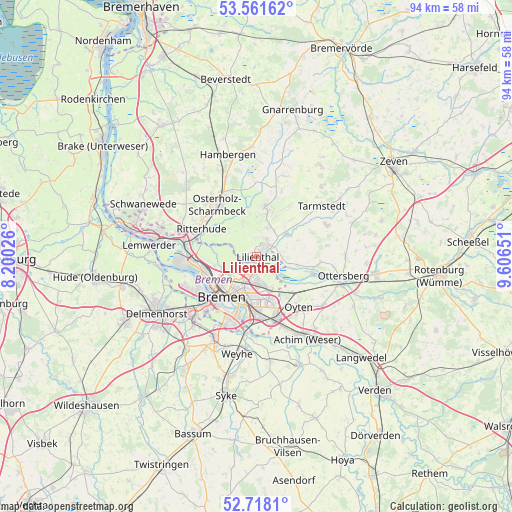
Lilienthal GPS coordinates[2]
53° 8' 30.948" North, 8° 54' 12.168" East
| Map corner | latitude | longitude |
|---|---|---|
| Upper-left | 53.56162°, | 8.20026° |
| Center: | 53.14193°, | 8.90338° |
| Lower-right: | 52.7181°, | 9.60651° |
| Map W x H: | 93.8×93.8 km | = 58.3×58.3mi |
| max Lat: | 55.01917° ⇑17.5% North |
| Lilienthal: | 53.14193° |
| min Lat: | ⇓82.5% South 47.40724° |
| min Long | Lilienthal | max Long |
| 5.92978° | 8.90338° | 14.98853° |
| W 33.4%⇐ | ⇒66.6% E |
Elevation
Elevation of Lilienthal is 3 m = 10 ft, and this is 246.1 m = 807 ft below average elevation for this country.
| Max E: |
1256 m = 4121 ft | 97.6% |
| Avg. | 249.1 m = 817 ft | |
| Lilienthal | 3 m = 10 ft | |
Min E: |
-5 m = -16 ft | 2.4% |
See also: Germany elevation on elevation.city.
Geographical zone
Lilienthal is located in North temperate zone (between Tropic of Cancer and the Arctic Circle). Distance of this North polar circle is 1492.3 km =927.3 mi to North.| Distance of | km | miles | from Lilienthal |
|---|---|---|---|
| North Pole | 4098.2 | 2546.5 | to North |
| Arctic Circle | 1492.3 | 927.3 | to North |
| Tropic Cancer | 3302.9 | 2052.3 | to South |
| Equator | 5908.8 | 3671.6 | to South |


Nearby cities:
15 places around Lilienthal: (largest is in red/bold)
• Achim
16.4 km =10.2 mi,  149°
149°
• Bremen
9.8 km =6.1 mi,  220°
220°
• Burglesum
14.5 km =9 mi,  280°
280°
• Grasberg
7 km =4.3 mi,  49°
49°
• Hepstedt
17.6 km =10.9 mi,  42°
42°
• Osterholz-Scharmbeck
11.9 km =7.4 mi,  322°
322°
• Ottersberg
16.4 km =10.2 mi,  102°
102°
• Oyten
12.7 km =7.9 mi,  143°
143°
• Ritterhude
12.1 km =7.5 mi,  292°
292°
• Stuhr
15.8 km =9.8 mi, 220°
• Tarmstedt
14.8 km =9.2 mi, 51°
• Vorwerk
17.1 km =10.6 mi,  74°
74°
• Westertimke
18.5 km =11.5 mi,  55°
55°
• Wilstedt
14.1 km =8.8 mi, 65°
• Worpswede
8.5 km =5.3 mi,  13°
13°
Sources, notices
• [Note1] Compared only with cities in Germany existing in our database
• [Src1] Map data: © OpenStreetMap contributors (CC-BY-SA)
• [Src2] Other city data from geonames.org with taken over terms of usage.
• [Src3] Geographical zone / Annual Mean Temperature by Robert A. Rohde @ Wikipedia
