Willenscharen geodata
Willenscharen (Schleswig-Holstein) is a seat of a fourth-order administrative division; located in Germany in Europe/Berlin (GMT+2) time zone. With population of 161 people, there are 10640 cities with bigger population in this country. Compared to other cities in Germany, 92.8% of cities are located further ↓South; 52.8% of cities are located further →East and 93.9% of cities have higher elevation than Willenscharen. Note1
Administrative division(s):
- Level 1: Schleswig-Holstein
- Level 3: Kreis Steinburg
- Level 4: Willenscharen


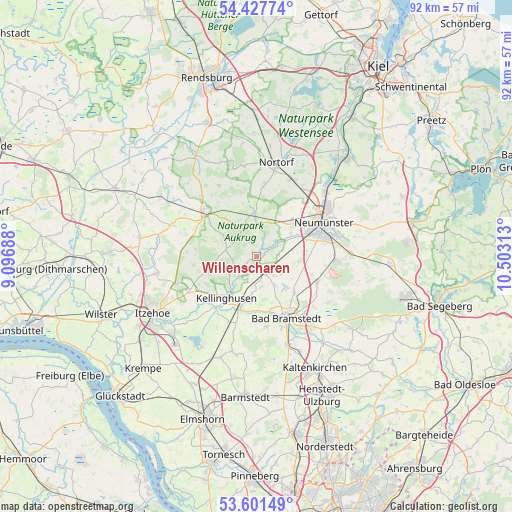
Willenscharen GPS coordinates[2]
54° 1' 0.012" North, 9° 48' 0" East
| Map corner | latitude | longitude |
|---|---|---|
| Upper-left | 54.42774°, | 9.09688° |
| Center: | 54.01667°, | 9.8° |
| Lower-right: | 53.60149°, | 10.50313° |
| Map W x H: | 91.9×91.9 km | = 57.1×57.1mi |
| max Lat: | 55.01917° ⇑7.2% North |
| Willenscharen: | 54.01667° |
| min Lat: | ⇓92.8% South 47.40724° |
| min Long | Willenscharen | max Long |
| 5.92978° | 9.8° | 14.98853° |
| W 47.2%⇐ | ⇒52.8% E |
Elevation
Elevation of Willenscharen is 11 m = 36 ft, and this is 238.1 m = 781 ft below average elevation for this country.
| Max E: |
1256 m = 4121 ft | 93.9% |
| Avg. | 249.1 m = 817 ft | |
| Willenscharen | 11 m = 36 ft | |
Min E: |
-5 m = -16 ft | 6.1% |
See also: Germany elevation on elevation.city.
Geographical zone
Willenscharen is located in North temperate zone (between Tropic of Cancer and the Arctic Circle). Distance of this North polar circle is 1395.1 km =866.9 mi to North.| Distance of | km | miles | from Willenscharen |
|---|---|---|---|
| North Pole | 4001 | 2486.1 | to North |
| Arctic Circle | 1395.1 | 866.9 | to North |
| Tropic Cancer | 3400.2 | 2112.8 | to South |
| Equator | 6006.1 | 3732 | to South |


Nearby cities:
15 places around Willenscharen: (largest is in red/bold)
• Armstedt
5.9 km =3.7 mi,  148°
148°
• Arpsdorf
4.7 km =2.9 mi,  66°
66°
• Borstel
5.5 km =3.4 mi,  180°
180°
• Brokstedt
3.9 km =2.4 mi,  163°
163°
• Fitzbek
2.9 km =1.8 mi,  229°
229°
• Hardebek
5.4 km =3.4 mi,  125°
125°
• Hasenkrug
4.9 km =3 mi,  138°
138°
• Hennstedt
5.7 km =3.5 mi,  288°
288°
• Oeschebüttel
6 km =3.7 mi,  239°
239°
• Poyenberg
6.8 km =4.2 mi, 285°
• Quarnstedt
6.9 km =4.3 mi,  186°
186°
• Rade
4.2 km =2.6 mi,  245°
245°
• Rosdorf
6.4 km =4 mi, 227°
• Sarlhusen
0.8 km =0.5 mi,  326°
326°
• Störkathen
4.9 km =3 mi,  221°
221°
Sources, notices
• [Note1] Compared only with cities in Germany existing in our database
• [Src1] Map data: © OpenStreetMap contributors (CC-BY-SA)
• [Src2] Other city data from geonames.org with taken over terms of usage.
• [Src3] Geographical zone / Annual Mean Temperature by Robert A. Rohde @ Wikipedia
