Brokstedt geodata
Brokstedt (Schleswig-Holstein) is a seat of a fourth-order administrative division; located in Germany in Europe/Berlin (GMT+2) time zone. With population of 2,224 people, there are 4776 cities with bigger population in this country. Compared to other cities in Germany, 92.4% of cities are located further ↓South; 52.6% of cities are located further →East and 94.8% of cities have higher elevation than Brokstedt. Note1


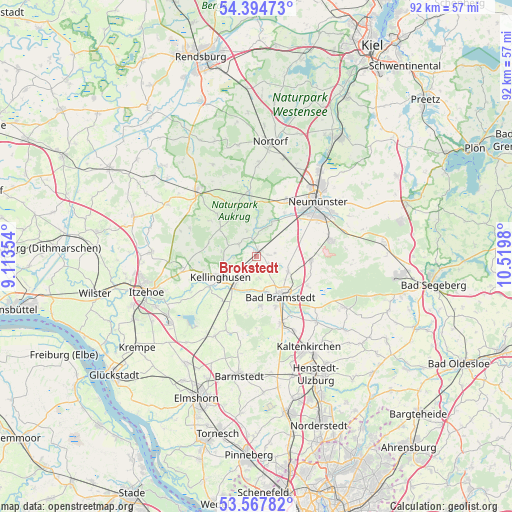
Brokstedt GPS coordinates[2]
53° 58' 59.988" North, 9° 49' 0.012" East
| Map corner | latitude | longitude |
|---|---|---|
| Upper-left | 54.39473°, | 9.11354° |
| Center: | 53.98333°, | 9.81667° |
| Lower-right: | 53.56782°, | 10.5198° |
| Map W x H: | 91.9×91.9 km | = 57.1×57.1mi |
| max Lat: | 55.01917° ⇑7.6% North |
| Brokstedt: | 53.98333° |
| min Lat: | ⇓92.4% South 47.40724° |
| min Long | Brokstedt | max Long |
| 5.92978° | 9.81667° | 14.98853° |
| W 47.4%⇐ | ⇒52.6% E |
Elevation
Elevation of Brokstedt is 9 m = 30 ft, and this is 240.1 m = 788 ft below average elevation for this country.
| Max E: |
1256 m = 4121 ft | 94.8% |
| Avg. | 249.1 m = 817 ft | |
| Brokstedt | 9 m = 30 ft | |
Min E: |
-5 m = -16 ft | 5.2% |
See also: Germany elevation on elevation.city.
Geographical zone
Brokstedt is located in North temperate zone (between Tropic of Cancer and the Arctic Circle). Distance of this North polar circle is 1398.8 km =869.2 mi to North.| Distance of | km | miles | from Brokstedt |
|---|---|---|---|
| North Pole | 4004.7 | 2488.4 | to North |
| Arctic Circle | 1398.8 | 869.2 | to North |
| Tropic Cancer | 3396.5 | 2110.5 | to South |
| Equator | 6002.4 | 3729.7 | to South |


Nearby cities:
15 places around Brokstedt: (largest is in red/bold)
• Armstedt
2.4 km =1.5 mi,  123°
123°
• Arpsdorf
6.4 km =4 mi,  30°
30°
• Borstel
2.1 km =1.3 mi,  212°
212°
• Fitzbek
3.8 km =2.4 mi,  299°
299°
• Hagen
4.1 km =2.5 mi,  170°
170°
• Hardebek
3.4 km =2.1 mi,  80°
80°
• Hasenkrug
2.2 km =1.4 mi,  90°
90°
• Oeschebüttel
6.3 km =3.9 mi,  275°
275°
• Quarnstedt
3.7 km =2.3 mi, 211°
• Rade
5.3 km =3.3 mi,  291°
291°
• Rosdorf
5.9 km =3.7 mi,  264°
264°
• Sarlhusen
4.7 km =2.9 mi,  340°
340°
• Störkathen
4.4 km =2.7 mi,  270°
270°
• Wiemersdorf
6.3 km =3.9 mi, 116°
• Willenscharen
3.9 km =2.4 mi, 343°
Sources, notices
• [Note1] Compared only with cities in Germany existing in our database
• [Src1] Map data: © OpenStreetMap contributors (CC-BY-SA)
• [Src2] Other city data from geonames.org with taken over terms of usage.
• [Src3] Geographical zone / Annual Mean Temperature by Robert A. Rohde @ Wikipedia
