Arpsdorf geodata
Arpsdorf (Schleswig-Holstein) is a seat of a fourth-order administrative division; located in Germany in Europe/Berlin (GMT+2) time zone. With population of 245 people, there are 10278 cities with bigger population in this country. Compared to other cities in Germany, 93.1% of cities are located further ↓South; 52% of cities are located further →East and 93.9% of cities have higher elevation than Arpsdorf. Note1
Administrative division(s):
- Level 1: Schleswig-Holstein
- Level 3: Kreis Rendsburg-Eckernförde
- Level 4: Arpsdorf


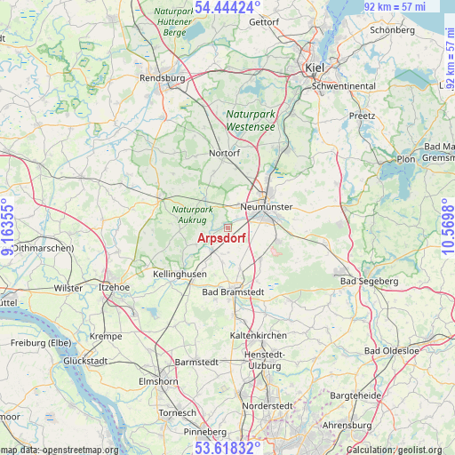
Arpsdorf GPS coordinates[2]
54° 1' 59.988" North, 9° 52' 0.012" East
| Map corner | latitude | longitude |
|---|---|---|
| Upper-left | 54.44424°, | 9.16355° |
| Center: | 54.03333°, | 9.86667° |
| Lower-right: | 53.61832°, | 10.5698° |
| Map W x H: | 91.8×91.8 km | = 57×57mi |
| max Lat: | 55.01917° ⇑6.9% North |
| Arpsdorf: | 54.03333° |
| min Lat: | ⇓93.1% South 47.40724° |
| min Long | Arpsdorf | max Long |
| 5.92978° | 9.86667° | 14.98853° |
| W 48%⇐ | ⇒52% E |
Elevation
Elevation of Arpsdorf is 11 m = 36 ft, and this is 238.1 m = 781 ft below average elevation for this country.
| Max E: |
1256 m = 4121 ft | 93.9% |
| Avg. | 249.1 m = 817 ft | |
| Arpsdorf | 11 m = 36 ft | |
Min E: |
-5 m = -16 ft | 6.1% |
See also: Germany elevation on elevation.city.
Geographical zone
Arpsdorf is located in North temperate zone (between Tropic of Cancer and the Arctic Circle). Distance of this North polar circle is 1393.2 km =865.7 mi to North.| Distance of | km | miles | from Arpsdorf |
|---|---|---|---|
| North Pole | 3999.1 | 2484.9 | to North |
| Arctic Circle | 1393.2 | 865.7 | to North |
| Tropic Cancer | 3402 | 2113.9 | to South |
| Equator | 6007.9 | 3733.1 | to South |


Nearby cities:
15 places around Arpsdorf: (largest is in red/bold)
• Armstedt
7 km =4.3 mi,  190°
190°
• Aukrug
7.8 km =4.8 mi,  315°
315°
• Borstel
8.5 km =5.3 mi,  210°
210°
• Brokstedt
6.4 km =4 mi, 210°
• Ehndorf
2.9 km =1.8 mi,  49°
49°
• Fitzbek
7.5 km =4.7 mi,  240°
240°
• Großenaspe
8.6 km =5.3 mi,  130°
130°
• Hardebek
5 km =3.1 mi,  178°
178°
• Hasenkrug
5.7 km =3.5 mi, 191°
• Neumünster
8.8 km =5.5 mi,  58°
58°
• Padenstedt
3.8 km =2.4 mi, 60°
• Sarlhusen
5 km =3.1 mi,  256°
256°
• Wasbek
5 km =3.1 mi,  23°
23°
• Wiemersdorf
8.7 km =5.4 mi,  164°
164°
• Willenscharen
4.7 km =2.9 mi,  246°
246°
Sources, notices
• [Note1] Compared only with cities in Germany existing in our database
• [Src1] Map data: © OpenStreetMap contributors (CC-BY-SA)
• [Src2] Other city data from geonames.org with taken over terms of usage.
• [Src3] Geographical zone / Annual Mean Temperature by Robert A. Rohde @ Wikipedia
