Wiggensbach geodata
Wiggensbach (Bavaria) is a populated place; located in Germany in Europe/Berlin (GMT+2) time zone. With population of 4,656 people, there are 2961 cities with bigger population in this country. Compared to other cities in Germany, 98.3% of cities are located further ↑North; 53.9% of cities are located further ←West and 99.6% of cities have lower elevation than Wiggensbach. Note1
Administrative division(s):
- Level 1: Bavaria
- Level 2: Swabia
- Level 3: Landkreis Oberallgäu
- Level 4: Wiggensbach, Markt


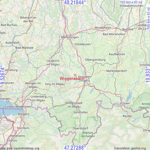
Wiggensbach GPS coordinates[2]
47° 44' 52.116" North, 10° 13' 47.532" East
| Map corner | latitude | longitude |
|---|---|---|
| Upper-left | 48.21844°, | 9.52674° |
| Center: | 47.74781°, | 10.22987° |
| Lower-right: | 47.27288°, | 10.933° |
| Map W x H: | 105.1×105.1 km | = 65.3×65.3mi |
| max Lat: | 55.01917° ⇑98.3% North |
| Wiggensbach: | 47.74781° |
| min Lat: | ⇓1.7% South 47.40724° |
| min Long | Wiggensbach | max Long |
| 5.92978° | 10.22987° | 14.98853° |
| W 53.9%⇐ | ⇒46.1% E |
Elevation
Elevation of Wiggensbach is 853 m = 2799 ft, and this is 603.9 m = 1981 ft above average elevation for this country.
| Max E: |
1256 m = 4121 ft | 0.40000000000001% |
| Wiggensbach | 853 m 2799 ft | |
| Avg. | 249.1 m = 817 ft | |
Min E: |
-5 m = -16 ft | 99.6% |
See also: Germany elevation on elevation.city.
Geographical zone
Wiggensbach is located in North temperate zone (between Tropic of Cancer and the Arctic Circle). Distance of this North polar circle is 2092.1 km =1300 mi to North.| Distance of | km | miles | from Wiggensbach |
|---|---|---|---|
| North Pole | 4698 | 2919.2 | to North |
| Arctic Circle | 2092.1 | 1300 | to North |
| Tropic Cancer | 2703.1 | 1679.6 | to South |
| Equator | 5309.1 | 3298.9 | to South |


Nearby cities:
15 places around Wiggensbach: (largest is in red/bold)
• Altusried
6.4 km =4 mi,  349°
349°
• Betzigau
11.6 km =7.2 mi,  97°
97°
• Buchenberg
5.8 km =3.6 mi,  173°
173°
• Dietmannsried
8 km =5 mi,  33°
33°
• Durach
10.4 km =6.5 mi,  124°
124°
• Haldenwang
10.7 km =6.6 mi,  57°
57°
• Kempten (Allgäu)
6.7 km =4.2 mi,  110°
110°
• Lauben
6.6 km =4.1 mi,  53°
53°
• Legau
14.2 km =8.8 mi,  328°
328°
• Neuburg
9.7 km =6 mi,  74°
74°
• Sulzberg
13.2 km =8.2 mi,  137°
137°
• Untrasried
14.9 km =9.3 mi, 50°
• Waltenhofen
10.1 km =6.3 mi,  145°
145°
• Weitnau
14.1 km =8.8 mi,  213°
213°
• Wildpoldsried
12.9 km =8 mi,  80°
80°
Sources, notices
• [Note1] Compared only with cities in Germany existing in our database
• [Src1] Map data: © OpenStreetMap contributors (CC-BY-SA)
• [Src2] Other city data from geonames.org with taken over terms of usage.
• [Src3] Geographical zone / Annual Mean Temperature by Robert A. Rohde @ Wikipedia
