Neuburg geodata
Neuburg (Bavaria) is a populated place; located in Germany in Europe/Berlin (GMT+2) time zone. With population of 3,209 people, there are 3820 cities with bigger population in this country. Compared to other cities in Germany, 98% of cities are located further ↑North; 56.5% of cities are located further ←West and 98.6% of cities have lower elevation than Neuburg. Note1
Administrative division(s):
- Level 1: Bavaria
- Level 2: Swabia
- Level 3: Landkreis Oberallgäu
- Level 4: Haldenwang


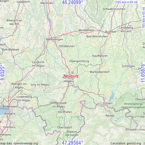
Neuburg GPS coordinates[2]
47° 46' 14.016" North, 10° 21' 20.268" East
| Map corner | latitude | longitude |
|---|---|---|
| Upper-left | 48.24099°, | 9.6525° |
| Center: | 47.77056°, | 10.35563° |
| Lower-right: | 47.29584°, | 11.05876° |
| Map W x H: | 105.1×105.1 km | = 65.3×65.3mi |
| max Lat: | 55.01917° ⇑98% North |
| Neuburg: | 47.77056° |
| min Lat: | ⇓2% South 47.40724° |
| min Long | Neuburg | max Long |
| 5.92978° | 10.35563° | 14.98853° |
| W 56.5%⇐ | ⇒43.5% E |
Elevation
Elevation of Neuburg is 740 m = 2428 ft, and this is 490.9 m = 1611 ft above average elevation for this country.
| Max E: |
1256 m = 4121 ft | 1.4% |
| Neuburg | 740 m 2428 ft | |
| Avg. | 249.1 m = 817 ft | |
Min E: |
-5 m = -16 ft | 98.6% |
See also: Germany elevation on elevation.city.
Geographical zone
Neuburg is located in North temperate zone (between Tropic of Cancer and the Arctic Circle). Distance of this North polar circle is 2089.6 km =1298.4 mi to North.| Distance of | km | miles | from Neuburg |
|---|---|---|---|
| North Pole | 4695.5 | 2917.6 | to North |
| Arctic Circle | 2089.6 | 1298.4 | to North |
| Tropic Cancer | 2705.7 | 1681.2 | to South |
| Equator | 5311.6 | 3300.5 | to South |


Nearby cities:
15 places around Neuburg: (largest is in red/bold)
• Altusried
11.2 km =7 mi,  289°
289°
• Betzigau
4.6 km =2.9 mi,  153°
153°
• Dietmannsried
6.5 km =4 mi,  310°
310°
• Durach
8.5 km =5.3 mi,  185°
185°
• Günzach
8.5 km =5.3 mi,  44°
44°
• Haldenwang
3.3 km =2.1 mi,  352°
352°
• Kempten (Allgäu)
5.8 km =3.6 mi,  212°
212°
• Kraftisried
8.7 km =5.4 mi,  83°
83°
• Lauben
4.4 km =2.7 mi, 288°
• Obergünzburg
9.5 km =5.9 mi,  29°
29°
• Unterthingau
11.1 km =6.9 mi,  89°
89°
• Untrasried
7.3 km =4.5 mi,  16°
16°
• Waltenhofen
11.4 km =7.1 mi,  198°
198°
• Wiggensbach
9.7 km =6 mi,  254°
254°
• Wildpoldsried
3.3 km =2.1 mi,  97°
97°
Sources, notices
• [Note1] Compared only with cities in Germany existing in our database
• [Src1] Map data: © OpenStreetMap contributors (CC-BY-SA)
• [Src2] Other city data from geonames.org with taken over terms of usage.
• [Src3] Geographical zone / Annual Mean Temperature by Robert A. Rohde @ Wikipedia
