Dietmannsried geodata
Dietmannsried (Bavaria) is a populated place; located in Germany in Europe/Berlin (GMT+2) time zone. With population of 8,044 people, there are 1951 cities with bigger population in this country. Compared to other cities in Germany, 97.6% of cities are located further ↑North; 55.2% of cities are located further ←West and 97.4% of cities have lower elevation than Dietmannsried. Note1
Administrative division(s):
- Level 1: Bavaria
- Level 2: Swabia
- Level 3: Landkreis Oberallgäu
- Level 4: Dietmannsried, Markt


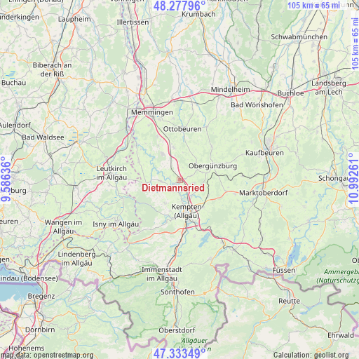
Dietmannsried GPS coordinates[2]
47° 48' 28.332" North, 10° 17' 22.128" East
| Map corner | latitude | longitude |
|---|---|---|
| Upper-left | 48.27796°, | 9.58636° |
| Center: | 47.80787°, | 10.28948° |
| Lower-right: | 47.33349°, | 10.99261° |
| Map W x H: | 105×105 km | = 65.2×65.2mi |
| max Lat: | 55.01917° ⇑97.6% North |
| Dietmannsried: | 47.80787° |
| min Lat: | ⇓2.4% South 47.40724° |
| min Long | Dietmannsried | max Long |
| 5.92978° | 10.28948° | 14.98853° |
| W 55.2%⇐ | ⇒44.8% E |
Elevation
Elevation of Dietmannsried is 680 m = 2231 ft, and this is 430.9 m = 1414 ft above average elevation for this country.
| Max E: |
1256 m = 4121 ft | 2.6% |
| Dietmannsried | 680 m 2231 ft | |
| Avg. | 249.1 m = 817 ft | |
Min E: |
-5 m = -16 ft | 97.4% |
See also: Germany elevation on elevation.city.
Geographical zone
Dietmannsried is located in North temperate zone (between Tropic of Cancer and the Arctic Circle). Distance of this North polar circle is 2085.4 km =1295.8 mi to North.| Distance of | km | miles | from Dietmannsried |
|---|---|---|---|
| North Pole | 4691.3 | 2915 | to North |
| Arctic Circle | 2085.4 | 1295.8 | to North |
| Tropic Cancer | 2709.8 | 1683.8 | to South |
| Equator | 5315.7 | 3303 | to South |


Nearby cities:
15 places around Dietmannsried: (largest is in red/bold)
• Altusried
5.6 km =3.5 mi,  265°
265°
• Betzigau
10.9 km =6.8 mi,  139°
139°
• Buchenberg
13 km =8.1 mi,  196°
196°
• Böhen
8.4 km =5.2 mi,  5°
5°
• Günzach
11.1 km =6.9 mi,  80°
80°
• Haldenwang
4.6 km =2.9 mi,  100°
100°
• Kempten (Allgäu)
9.2 km =5.7 mi,  168°
168°
• Lauben
2.8 km =1.7 mi,  163°
163°
• Legau
13.1 km =8.1 mi,  294°
294°
• Neuburg
6.5 km =4 mi,  130°
130°
• Obergünzburg
10.5 km =6.5 mi,  66°
66°
• Untrasried
7.6 km =4.7 mi, 68°
• Wiggensbach
8 km =5 mi,  213°
213°
• Wildpoldsried
9.4 km =5.8 mi,  119°
119°
• Wolfertschwenden
9.7 km =6 mi,  350°
350°
Sources, notices
• [Note1] Compared only with cities in Germany existing in our database
• [Src1] Map data: © OpenStreetMap contributors (CC-BY-SA)
• [Src2] Other city data from geonames.org with taken over terms of usage.
• [Src3] Geographical zone / Annual Mean Temperature by Robert A. Rohde @ Wikipedia
