Wernau geodata
Wernau (Baden-Württemberg) is a populated place; located in Germany in Europe/Berlin (GMT+2) time zone. With population of 12,518 people, there are 1295 cities with bigger population in this country. Compared to other cities in Germany, 86.5% of cities are located further ↑North; 59.1% of cities are located further →East and 55.3% of cities have lower elevation than Wernau. Note1
Administrative division(s):
- Level 1: Baden-Württemberg
- Level 2: Regierungsbezirk Stuttgart
- Level 3: Landkreis Esslingen
- Level 4: Wernau (Neckar)


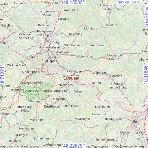
Wernau GPS coordinates[2]
48° 41' 35.016" North, 9° 24' 55.188" East
| Map corner | latitude | longitude |
|---|---|---|
| Upper-left | 49.15505°, | 8.71221° |
| Center: | 48.69306°, | 9.41533° |
| Lower-right: | 48.22679°, | 10.11846° |
| Map W x H: | 103.2×103.2 km | = 64.1×64.1mi |
| max Lat: | 55.01917° ⇑86.5% North |
| Wernau: | 48.69306° |
| min Lat: | ⇓13.5% South 47.40724° |
| min Long | Wernau | max Long |
| 5.92978° | 9.41533° | 14.98853° |
| W 40.9%⇐ | ⇒59.1% E |
Elevation
Elevation of Wernau is 260 m = 853 ft, and this is 10.9 m = 36 ft above average elevation for this country.
| Max E: |
1256 m = 4121 ft | 44.7% |
| Wernau | 260 m 853 ft | |
| Avg. | 249.1 m = 817 ft | |
Min E: |
-5 m = -16 ft | 55.3% |
See also: Germany elevation on elevation.city.
Geographical zone
Wernau is located in North temperate zone (between Tropic of Cancer and the Arctic Circle). Distance of this North polar circle is 1987 km =1234.7 mi to North.| Distance of | km | miles | from Wernau |
|---|---|---|---|
| North Pole | 4592.9 | 2853.9 | to North |
| Arctic Circle | 1987 | 1234.7 | to North |
| Tropic Cancer | 2808.2 | 1744.9 | to South |
| Equator | 5414.2 | 3364.2 | to South |


Nearby cities:
15 places around Wernau: (largest is in red/bold)
• Altbach
4.2 km =2.6 mi,  322°
322°
• Baltmannsweiler
6 km =3.7 mi,  24°
24°
• Deizisau
3 km =1.9 mi,  314°
314°
• Denkendorf
7.2 km =4.5 mi,  272°
272°
• Ebersbach an der Fils
8.3 km =5.2 mi,  72°
72°
• Hochdorf
3.6 km =2.2 mi,  90°
90°
• Kirchheim unter Teck
5.9 km =3.7 mi,  151°
151°
• Köngen
3.7 km =2.3 mi,  253°
253°
• Notzingen
3.9 km =2.4 mi,  128°
128°
• Oberboihingen
6 km =3.7 mi,  216°
216°
• Plochingen
2 km =1.2 mi,  8°
8°
• Reichenbach an der Fils
4.1 km =2.5 mi,  62°
62°
• Schlierbach
7.8 km =4.8 mi,  105°
105°
• Unterensingen
6 km =3.7 mi, 224°
• Wendlingen am Neckar
3.8 km =2.4 mi,  229°
229°
Sources, notices
• [Note1] Compared only with cities in Germany existing in our database
• [Src1] Map data: © OpenStreetMap contributors (CC-BY-SA)
• [Src2] Other city data from geonames.org with taken over terms of usage.
• [Src3] Geographical zone / Annual Mean Temperature by Robert A. Rohde @ Wikipedia
