Weingarten geodata
Weingarten (Rheinland-Pfalz) is a populated place; located in Germany in Europe/Berlin (GMT+2) time zone. With population of 1,532 people, there are 5819 cities with bigger population in this country. Compared to other cities in Germany, 79.4% of cities are located further ↑North; 73.1% of cities are located further →East and 64.1% of cities have higher elevation than Weingarten. Note1
Administrative division(s):
- Level 1: Rheinland-Pfalz
- Level 3: Landkreis Germersheim
- Level 4: Weingarten (Pfalz)


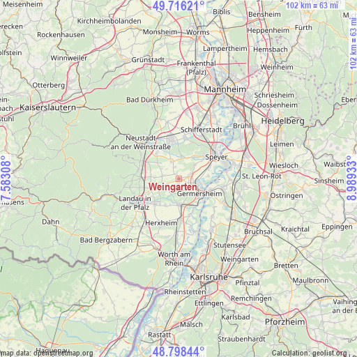
Weingarten GPS coordinates[2]
49° 15' 34.056" North, 8° 17' 10.32" East
| Map corner | latitude | longitude |
|---|---|---|
| Upper-left | 49.71621°, | 7.58308° |
| Center: | 49.25946°, | 8.2862° |
| Lower-right: | 48.79844°, | 8.98933° |
| Map W x H: | 102×102 km | = 63.4×63.4mi |
| max Lat: | 55.01917° ⇑79.4% North |
| Weingarten: | 49.25946° |
| min Lat: | ⇓20.6% South 47.40724° |
| min Long | Weingarten | max Long |
| 5.92978° | 8.2862° | 14.98853° |
| W 26.9%⇐ | ⇒73.1% E |
Elevation
Elevation of Weingarten is 126 m = 413 ft, and this is 123.1 m = 404 ft below average elevation for this country.
| Max E: |
1256 m = 4121 ft | 64.1% |
| Avg. | 249.1 m = 817 ft | |
| Weingarten | 126 m = 413 ft | |
Min E: |
-5 m = -16 ft | 35.9% |
See also: Germany elevation on elevation.city.
Geographical zone
Weingarten is located in North temperate zone (between Tropic of Cancer and the Arctic Circle). Distance of this North polar circle is 1924 km =1195.5 mi to North.| Distance of | km | miles | from Weingarten |
|---|---|---|---|
| North Pole | 4529.9 | 2814.7 | to North |
| Arctic Circle | 1924 | 1195.5 | to North |
| Tropic Cancer | 2871.2 | 1784.1 | to South |
| Equator | 5477.1 | 3403.3 | to South |


Nearby cities:
15 places around Weingarten: (largest is in red/bold)
• Altdorf
5.9 km =3.7 mi,  301°
301°
• Bellheim
6.8 km =4.2 mi,  184°
184°
• Böbingen
4.5 km =2.8 mi,  307°
307°
• Freimersheim
4.7 km =2.9 mi,  284°
284°
• Freisbach
1.7 km =1.1 mi,  322°
322°
• Germersheim
6.9 km =4.3 mi,  125°
125°
• Gommersheim
3.8 km =2.4 mi,  337°
337°
• Harthausen
5.8 km =3.6 mi,  47°
47°
• Hochstadt
5.8 km =3.6 mi,  256°
256°
• Kleinfischlingen
7.2 km =4.5 mi,  273°
273°
• Lingenfeld
3.9 km =2.4 mi,  99°
99°
• Lustadt
1.9 km =1.2 mi,  208°
208°
• Schwegenheim
3.3 km =2.1 mi,  69°
69°
• Westheim
3.1 km =1.9 mi,  118°
118°
• Zeiskam
4.1 km =2.5 mi,  223°
223°
Sources, notices
• [Note1] Compared only with cities in Germany existing in our database
• [Src1] Map data: © OpenStreetMap contributors (CC-BY-SA)
• [Src2] Other city data from geonames.org with taken over terms of usage.
• [Src3] Geographical zone / Annual Mean Temperature by Robert A. Rohde @ Wikipedia
