Gommersheim geodata
Gommersheim (Rheinland-Pfalz) is a seat of a fourth-order administrative division; located in Germany in Europe/Berlin (GMT+2) time zone. With population of 1,313 people, there are 6270 cities with bigger population in this country. Compared to other cities in Germany, 78.9% of cities are located further ↑North; 73.3% of cities are located further →East and 65.8% of cities have higher elevation than Gommersheim. Note1
Administrative division(s):
- Level 1: Rheinland-Pfalz
- Level 3: Landkreis Südliche Weinstraße
- Level 4: Gommersheim


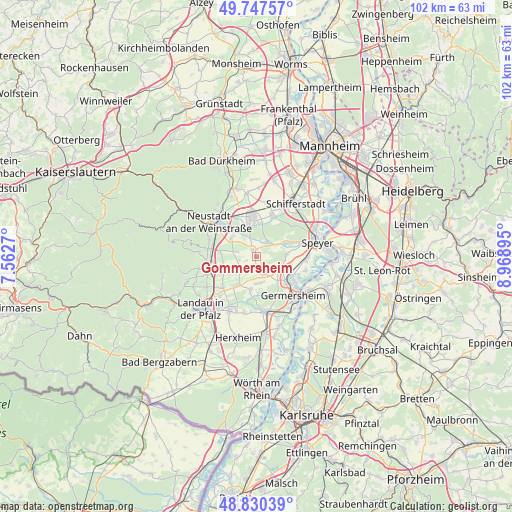
Gommersheim GPS coordinates[2]
49° 17' 27.996" North, 8° 15' 56.988" East
| Map corner | latitude | longitude |
|---|---|---|
| Upper-left | 49.74757°, | 7.5627° |
| Center: | 49.29111°, | 8.26583° |
| Lower-right: | 48.83039°, | 8.96895° |
| Map W x H: | 102×102 km | = 63.4×63.4mi |
| max Lat: | 55.01917° ⇑78.9% North |
| Gommersheim: | 49.29111° |
| min Lat: | ⇓21.1% South 47.40724° |
| min Long | Gommersheim | max Long |
| 5.92978° | 8.26583° | 14.98853° |
| W 26.7%⇐ | ⇒73.3% E |
Elevation
Elevation of Gommersheim is 115 m = 377 ft, and this is 134.1 m = 440 ft below average elevation for this country.
| Max E: |
1256 m = 4121 ft | 65.8% |
| Avg. | 249.1 m = 817 ft | |
| Gommersheim | 115 m = 377 ft | |
Min E: |
-5 m = -16 ft | 34.2% |
See also: Germany elevation on elevation.city.
Geographical zone
Gommersheim is located in North temperate zone (between Tropic of Cancer and the Arctic Circle). Distance of this North polar circle is 1920.5 km =1193.3 mi to North.| Distance of | km | miles | from Gommersheim |
|---|---|---|---|
| North Pole | 4526.4 | 2812.6 | to North |
| Arctic Circle | 1920.5 | 1193.3 | to North |
| Tropic Cancer | 2874.7 | 1786.3 | to South |
| Equator | 5480.7 | 3405.5 | to South |


Nearby cities:
15 places around Gommersheim: (largest is in red/bold)
• Altdorf
3.6 km =2.2 mi,  263°
263°
• Böbingen
2.2 km =1.4 mi,  250°
250°
• Freimersheim
3.9 km =2.4 mi,  232°
232°
• Freisbach
2.2 km =1.4 mi,  168°
168°
• Hanhofen
6.1 km =3.8 mi,  62°
62°
• Harthausen
5.8 km =3.6 mi,  86°
86°
• Hochstadt
6.4 km =4 mi,  220°
220°
• Kleinfischlingen
6.5 km =4 mi,  241°
241°
• Lachen-Speyerdorf
6.5 km =4 mi,  312°
312°
• Lingenfeld
6.7 km =4.2 mi,  128°
128°
• Lustadt
5.2 km =3.2 mi, 173°
• Schwegenheim
5.1 km =3.2 mi,  117°
117°
• Weingarten
3.8 km =2.4 mi,  157°
157°
• Westheim
6.5 km =4 mi,  139°
139°
• Zeiskam
6.6 km =4.1 mi,  191°
191°
Sources, notices
• [Note1] Compared only with cities in Germany existing in our database
• [Src1] Map data: © OpenStreetMap contributors (CC-BY-SA)
• [Src2] Other city data from geonames.org with taken over terms of usage.
• [Src3] Geographical zone / Annual Mean Temperature by Robert A. Rohde @ Wikipedia
