Lustadt geodata
Lustadt (Rheinland-Pfalz) is a seat of a fourth-order administrative division; located in Germany in Europe/Berlin (GMT+2) time zone. With population of 3,291 people, there are 3759 cities with bigger population in this country. Compared to other cities in Germany, 79.7% of cities are located further ↑North; 73.2% of cities are located further →East and 65.2% of cities have higher elevation than Lustadt. Note1
Administrative division(s):
- Level 1: Rheinland-Pfalz
- Level 3: Landkreis Germersheim
- Level 4: Lustadt


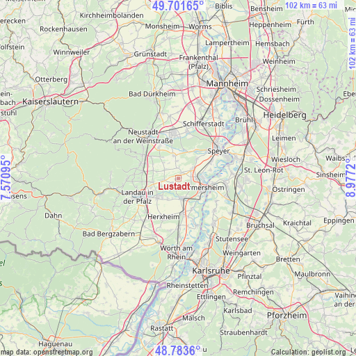
Lustadt GPS coordinates[2]
49° 14' 41.136" North, 8° 16' 26.652" East
| Map corner | latitude | longitude |
|---|---|---|
| Upper-left | 49.70165°, | 7.57095° |
| Center: | 49.24476°, | 8.27407° |
| Lower-right: | 48.7836°, | 8.9772° |
| Map W x H: | 102.1×102.1 km | = 63.4×63.4mi |
| max Lat: | 55.01917° ⇑79.7% North |
| Lustadt: | 49.24476° |
| min Lat: | ⇓20.3% South 47.40724° |
| min Long | Lustadt | max Long |
| 5.92978° | 8.27407° | 14.98853° |
| W 26.8%⇐ | ⇒73.2% E |
Elevation
Elevation of Lustadt is 119 m = 390 ft, and this is 130.1 m = 427 ft below average elevation for this country.
| Max E: |
1256 m = 4121 ft | 65.2% |
| Avg. | 249.1 m = 817 ft | |
| Lustadt | 119 m = 390 ft | |
Min E: |
-5 m = -16 ft | 34.8% |
See also: Germany elevation on elevation.city.
Geographical zone
Lustadt is located in North temperate zone (between Tropic of Cancer and the Arctic Circle). Distance of this North polar circle is 1925.7 km =1196.6 mi to North.| Distance of | km | miles | from Lustadt |
|---|---|---|---|
| North Pole | 4531.6 | 2815.8 | to North |
| Arctic Circle | 1925.7 | 1196.6 | to North |
| Tropic Cancer | 2869.6 | 1783.1 | to South |
| Equator | 5475.5 | 3402.3 | to South |


Nearby cities:
15 places around Lustadt: (largest is in red/bold)
• Altdorf
6.3 km =3.9 mi,  318°
318°
• Bellheim
5.2 km =3.2 mi,  175°
175°
• Böbingen
5.2 km =3.2 mi,  328°
328°
• Freimersheim
4.6 km =2.9 mi,  307°
307°
• Freisbach
3 km =1.9 mi,  357°
357°
• Gommersheim
5.2 km =3.2 mi,  353°
353°
• Hochstadt
4.7 km =2.9 mi,  273°
273°
• Kleinfischlingen
6.7 km =4.2 mi,  288°
288°
• Knittelsheim
6.1 km =3.8 mi,  195°
195°
• Lingenfeld
4.8 km =3 mi,  77°
77°
• Ottersheim
6.7 km =4.2 mi,  207°
207°
• Schwegenheim
4.9 km =3 mi,  54°
54°
• Weingarten
1.9 km =1.2 mi,  28°
28°
• Westheim
3.6 km =2.2 mi,  87°
87°
• Zeiskam
2.4 km =1.5 mi,  235°
235°
Sources, notices
• [Note1] Compared only with cities in Germany existing in our database
• [Src1] Map data: © OpenStreetMap contributors (CC-BY-SA)
• [Src2] Other city data from geonames.org with taken over terms of usage.
• [Src3] Geographical zone / Annual Mean Temperature by Robert A. Rohde @ Wikipedia
