Weil am Rhein geodata
Weil am Rhein (Baden-Württemberg) is a populated place; located in Germany in Europe/Berlin (GMT+2) time zone. With population of 29,548 people, there are 475 cities with bigger population in this country. Compared to other cities in Germany, 99.6% of cities are located further ↑North; 84.5% of cities are located further →East and 57.8% of cities have lower elevation than Weil am Rhein. Note1
Administrative division(s):
- Level 1: Baden-Württemberg
- Level 2: Freiburg Region
- Level 3: Landkreis Lörrach
- Level 4: Weil am Rhein


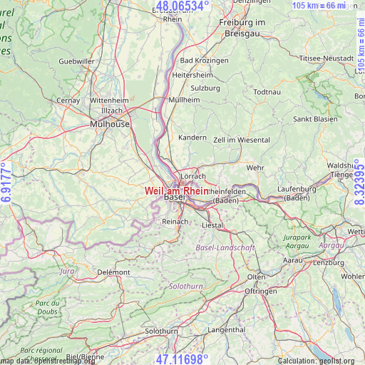
Weil am Rhein GPS coordinates[2]
47° 35' 35.916" North, 7° 37' 14.952" East
| Map corner | latitude | longitude |
|---|---|---|
| Upper-left | 48.06534°, | 6.9177° |
| Center: | 47.59331°, | 7.62082° |
| Lower-right: | 47.11698°, | 8.32395° |
| Map W x H: | 105.4×105.4 km | = 65.5×65.5mi |
| max Lat: | 55.01917° ⇑99.6% North |
| Weil am Rhein: | 47.59331° |
| min Lat: | ⇓0.4% South 47.40724° |
| min Long | Weil am Rhein | max Long |
| 5.92978° | 7.62082° | 14.98853° |
| W 15.5%⇐ | ⇒84.5% E |
Elevation
Elevation of Weil am Rhein is 277 m = 909 ft, and this is 27.9 m = 92 ft above average elevation for this country.
| Max E: |
1256 m = 4121 ft | 42.2% |
| Weil am Rhein | 277 m 909 ft | |
| Avg. | 249.1 m = 817 ft | |
Min E: |
-5 m = -16 ft | 57.8% |
See also: Germany elevation on elevation.city.
Geographical zone
Weil am Rhein is located in North temperate zone (between Tropic of Cancer and the Arctic Circle). Distance of this North polar circle is 2109.3 km =1310.7 mi to North.| Distance of | km | miles | from Weil am Rhein |
|---|---|---|---|
| North Pole | 4715.2 | 2929.9 | to North |
| Arctic Circle | 2109.3 | 1310.7 | to North |
| Tropic Cancer | 2686 | 1669 | to South |
| Equator | 5291.9 | 3288.2 | to South |


Nearby cities:
15 places around Weil am Rhein: (largest is in red/bold)
• Bad Bellingen
16.1 km =10 mi,  342°
342°
• Binzen
4.5 km =2.8 mi,  356°
356°
• Efringen-Kirchen
7.5 km =4.7 mi,  327°
327°
• Eimeldingen
4.7 km =2.9 mi, 340°
• Fischingen
6.5 km =4 mi,  346°
346°
• Grenzach-Wyhlen
6.7 km =4.2 mi,  135°
135°
• Inzlingen
5.3 km =3.3 mi,  95°
95°
• Kandern
13.8 km =8.6 mi,  13°
13°
• Lörrach
4.1 km =2.5 mi,  53°
53°
• Maulburg
13.4 km =8.3 mi,  64°
64°
• Rheinfelden
13 km =8.1 mi,  106°
106°
• Rümmingen
5.6 km =3.5 mi,  16°
16°
• Schallbach
6.4 km =4 mi, 8°
• Steinen
10.5 km =6.5 mi, 57°
• Wittlingen
7.3 km =4.5 mi, 18°
In other languages:
- In France: Weil-am-Rhein
- In Russian: Вайль-на-Рейне, Вайль-ам-Райн
- In Chinese: 莱茵河畔魏尔
Sources, notices
• [Note1] Compared only with cities in Germany existing in our database
• [Src1] Map data: © OpenStreetMap contributors (CC-BY-SA)
• [Src2] Other city data from geonames.org with taken over terms of usage.
• [Src3] Geographical zone / Annual Mean Temperature by Robert A. Rohde @ Wikipedia
