Wees geodata
Wees (Schleswig-Holstein) is a seat of a fourth-order administrative division; located in Germany in Europe/Berlin (GMT+1) time zone. With population of 2,247 people, there are 4745 cities with bigger population in this country. Compared to other cities in Germany, 99.7% of cities are located further ↓South; 57.5% of cities are located further →East and 79.9% of cities have higher elevation than Wees. Note1
Administrative division(s):
- Level 1: Schleswig-Holstein
- Level 3: Kreis Schleswig-Flensburg
- Level 4: Wees


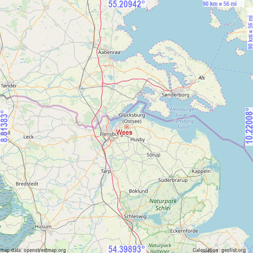
Wees GPS coordinates[2]
54° 48' 22.356" North, 9° 31' 1.02" East
| Map corner | latitude | longitude |
|---|---|---|
| Upper-left | 55.20942°, | 8.81383° |
| Center: | 54.80621°, | 9.51695° |
| Lower-right: | 54.39893°, | 10.22008° |
| Map W x H: | 90.1×90.1 km | = 56×56mi |
| max Lat: | 55.01917° ⇑0.3% North |
| Wees: | 54.80621° |
| min Lat: | ⇓99.7% South 47.40724° |
| min Long | Wees | max Long |
| 5.92978° | 9.51695° | 14.98853° |
| W 42.5%⇐ | ⇒57.5% E |
Elevation
Elevation of Wees is 47 m = 154 ft, and this is 202.1 m = 663 ft below average elevation for this country.
| Max E: |
1256 m = 4121 ft | 79.9% |
| Avg. | 249.1 m = 817 ft | |
| Wees | 47 m = 154 ft | |
Min E: |
-5 m = -16 ft | 20.1% |
See also: Germany elevation on elevation.city.
Geographical zone
Wees is located in North temperate zone (between Tropic of Cancer and the Arctic Circle). Distance of this North polar circle is 1307.3 km =812.3 mi to North.| Distance of | km | miles | from Wees |
|---|---|---|---|
| North Pole | 3913.2 | 2431.5 | to North |
| Arctic Circle | 1307.3 | 812.3 | to North |
| Tropic Cancer | 3488 | 2167.3 | to South |
| Equator | 6093.9 | 3786.6 | to South |


Nearby cities:
15 places around Wees: (largest is in red/bold)
• Ausacker
8.7 km =5.4 mi,  158°
158°
• Flensburg
5.5 km =3.4 mi,  243°
243°
• Freienwill
8.9 km =5.5 mi,  189°
189°
• Glücksburg
3.8 km =2.4 mi,  32°
32°
• Grundhof
9.6 km =6 mi,  114°
114°
• Harrislee
8.6 km =5.3 mi,  265°
265°
• Husby
6.1 km =3.8 mi,  135°
135°
• Hürup
6.3 km =3.9 mi,  170°
170°
• Jarplund-Weding
10 km =6.2 mi,  219°
219°
• Langballig
7.5 km =4.7 mi,  95°
95°
• Maasbüll
3.3 km =2.1 mi, 171°
• Munkbrarup
3.3 km =2.1 mi, 102°
• Ringsberg
5.2 km =3.2 mi,  89°
89°
• Tastrup
4.9 km =3 mi,  206°
206°
• Westerholz
9.7 km =6 mi,  83°
83°
Sources, notices
• [Note1] Compared only with cities in Germany existing in our database
• [Src1] Map data: © OpenStreetMap contributors (CC-BY-SA)
• [Src2] Other city data from geonames.org with taken over terms of usage.
• [Src3] Geographical zone / Annual Mean Temperature by Robert A. Rohde @ Wikipedia
