Glücksburg geodata
Glücksburg (Schleswig-Holstein) is a populated place; located in Germany in Europe/Berlin (GMT+2) time zone. With population of 5,946 people, there are 2478 cities with bigger population in this country. Compared to other cities in Germany, 99.8% of cities are located further ↓South; 57.1% of cities are located further →East and 90.9% of cities have higher elevation than Glücksburg. Note1
Administrative division(s):
- Level 1: Schleswig-Holstein
- Level 3: Kreis Schleswig-Flensburg
- Level 4: Glücksburg (Ostsee)


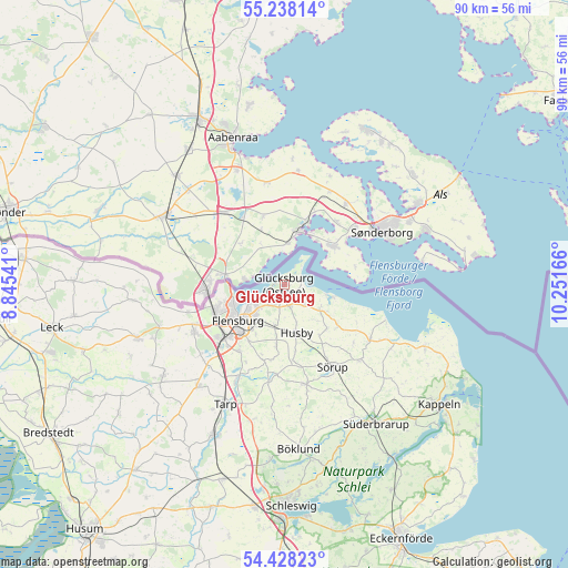
Glücksburg GPS coordinates[2]
54° 50' 6.792" North, 9° 32' 54.708" East
| Map corner | latitude | longitude |
|---|---|---|
| Upper-left | 55.23814°, | 8.84541° |
| Center: | 54.83522°, | 9.54853° |
| Lower-right: | 54.42823°, | 10.25166° |
| Map W x H: | 90.1×90.1 km | = 56×56mi |
| max Lat: | 55.01917° ⇑0.2% North |
| Glücksburg: | 54.83522° |
| min Lat: | ⇓99.8% South 47.40724° |
| min Long | Glücksburg | max Long |
| 5.92978° | 9.54853° | 14.98853° |
| W 42.9%⇐ | ⇒57.1% E |
Elevation
Elevation of Glücksburg is 19 m = 62 ft, and this is 230.1 m = 755 ft below average elevation for this country.
| Max E: |
1256 m = 4121 ft | 90.9% |
| Avg. | 249.1 m = 817 ft | |
| Glücksburg | 19 m = 62 ft | |
Min E: |
-5 m = -16 ft | 9.1% |
See also: Germany elevation on elevation.city.
Geographical zone
Glücksburg is located in North temperate zone (between Tropic of Cancer and the Arctic Circle). Distance of this North polar circle is 1304.1 km =810.3 mi to North.| Distance of | km | miles | from Glücksburg |
|---|---|---|---|
| North Pole | 3910 | 2429.6 | to North |
| Arctic Circle | 1304.1 | 810.3 | to North |
| Tropic Cancer | 3491.2 | 2169.3 | to South |
| Equator | 6097.1 | 3788.6 | to South |


Nearby cities:
15 places around Glücksburg: (largest is in red/bold)
• Ausacker
11.4 km =7.1 mi,  174°
174°
• Dollerup
10.5 km =6.5 mi,  127°
127°
• Flensburg
9 km =5.6 mi,  230°
230°
• Freienwill
12.5 km =7.8 mi,  196°
196°
• Grundhof
9.8 km =6.1 mi,  136°
136°
• Harrislee
11.3 km =7 mi,  249°
249°
• Husby
7.9 km =4.9 mi,  163°
163°
• Hürup
9.5 km =5.9 mi,  185°
185°
• Langballig
6.7 km =4.2 mi, 125°
• Maasbüll
6.7 km =4.2 mi, 193°
• Munkbrarup
4.1 km =2.5 mi, 163°
• Ringsberg
4.5 km =2.8 mi, 134°
• Tastrup
8.7 km =5.4 mi,  208°
208°
• Wees
3.8 km =2.4 mi, 212°
• Westerholz
7.8 km =4.8 mi,  105°
105°
Sources, notices
• [Note1] Compared only with cities in Germany existing in our database
• [Src1] Map data: © OpenStreetMap contributors (CC-BY-SA)
• [Src2] Other city data from geonames.org with taken over terms of usage.
• [Src3] Geographical zone / Annual Mean Temperature by Robert A. Rohde @ Wikipedia
