Hürup geodata
Hürup (Schleswig-Holstein) is a seat of a fourth-order administrative division; located in Germany in Europe/Berlin (GMT+2) time zone. With population of 1,180 people, there are 6618 cities with bigger population in this country. Compared to other cities in Germany, 99.4% of cities are located further ↓South; 57.3% of cities are located further →East and 81% of cities have higher elevation than Hürup. Note1
Administrative division(s):
- Level 1: Schleswig-Holstein
- Level 3: Kreis Schleswig-Flensburg
- Level 4: Hürup


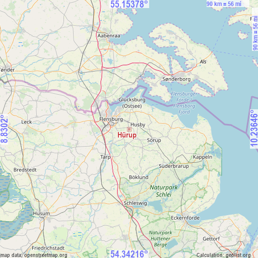
Hürup GPS coordinates[2]
54° 45' 0" North, 9° 31' 59.988" East
| Map corner | latitude | longitude |
|---|---|---|
| Upper-left | 55.15378°, | 8.8302° |
| Center: | 54.75°, | 9.53333° |
| Lower-right: | 54.34216°, | 10.23646° |
| Map W x H: | 90.2×90.2 km | = 56×56mi |
| max Lat: | 55.01917° ⇑0.6% North |
| Hürup: | 54.75° |
| min Lat: | ⇓99.4% South 47.40724° |
| min Long | Hürup | max Long |
| 5.92978° | 9.53333° | 14.98853° |
| W 42.7%⇐ | ⇒57.3% E |
Elevation
Elevation of Hürup is 44 m = 144 ft, and this is 205.1 m = 673 ft below average elevation for this country.
| Max E: |
1256 m = 4121 ft | 81% |
| Avg. | 249.1 m = 817 ft | |
| Hürup | 44 m = 144 ft | |
Min E: |
-5 m = -16 ft | 19% |
See also: Germany elevation on elevation.city.
Geographical zone
Hürup is located in North temperate zone (between Tropic of Cancer and the Arctic Circle). Distance of this North polar circle is 1313.5 km =816.2 mi to North.| Distance of | km | miles | from Hürup |
|---|---|---|---|
| North Pole | 3919.4 | 2435.4 | to North |
| Arctic Circle | 1313.5 | 816.2 | to North |
| Tropic Cancer | 3481.7 | 2163.4 | to South |
| Equator | 6087.6 | 3782.7 | to South |


Nearby cities:
15 places around Hürup: (largest is in red/bold)
• Ausacker
2.8 km =1.7 mi,  130°
130°
• Flensburg
7.1 km =4.4 mi,  302°
302°
• Freienwill
3.5 km =2.2 mi,  225°
225°
• Großsolt
5.7 km =3.5 mi,  190°
190°
• Grundhof
8 km =5 mi,  73°
73°
• Husby
3.7 km =2.3 mi,  59°
59°
• Jarplund-Weding
7.5 km =4.7 mi,  259°
259°
• Langballig
8.5 km =5.3 mi,  49°
49°
• Maasbüll
3 km =1.9 mi,  348°
348°
• Munkbrarup
6 km =3.7 mi,  21°
21°
• Ringsberg
7.6 km =4.7 mi,  33°
33°
• Sankelmark
7.9 km =4.9 mi,  243°
243°
• Satrup
7.9 km =4.9 mi,  144°
144°
• Tastrup
3.7 km =2.3 mi, 300°
• Wees
6.3 km =3.9 mi, 350°
Sources, notices
• [Note1] Compared only with cities in Germany existing in our database
• [Src1] Map data: © OpenStreetMap contributors (CC-BY-SA)
• [Src2] Other city data from geonames.org with taken over terms of usage.
• [Src3] Geographical zone / Annual Mean Temperature by Robert A. Rohde @ Wikipedia
