Wasenbach geodata
Wasenbach (Rheinland-Pfalz) is a seat of a fourth-order administrative division; located in Germany in Europe/Berlin (GMT+2) time zone. With population of 359 people, there are 9834 cities with bigger population in this country. Compared to other cities in Germany, 56.5% of cities are located further ↑North; 77.8% of cities are located further →East and 52.7% of cities have lower elevation than Wasenbach. Note1


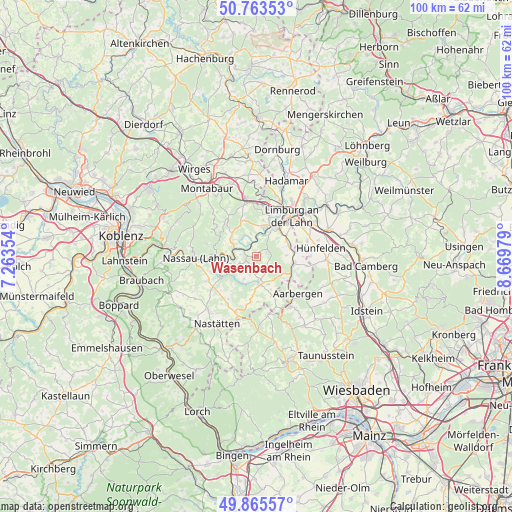
Wasenbach GPS coordinates[2]
50° 19' 0.012" North, 7° 58' 0.012" East
| Map corner | latitude | longitude |
|---|---|---|
| Upper-left | 50.76353°, | 7.26354° |
| Center: | 50.31667°, | 7.96667° |
| Lower-right: | 49.86557°, | 8.66979° |
| Map W x H: | 99.8×99.8 km | = 62×62mi |
| max Lat: | 55.01917° ⇑56.5% North |
| Wasenbach: | 50.31667° |
| min Lat: | ⇓43.5% South 47.40724° |
| min Long | Wasenbach | max Long |
| 5.92978° | 7.96667° | 14.98853° |
| W 22.2%⇐ | ⇒77.8% E |
Elevation
Elevation of Wasenbach is 244 m = 801 ft, and this is 5.1 m = 17 ft below average elevation for this country.
| Max E: |
1256 m = 4121 ft | 47.3% |
| Avg. | 249.1 m = 817 ft | |
| Wasenbach | 244 m = 801 ft | |
Min E: |
-5 m = -16 ft | 52.7% |
See also: Germany elevation on elevation.city.
Geographical zone
Wasenbach is located in North temperate zone (between Tropic of Cancer and the Arctic Circle). Distance of this North polar circle is 1806.5 km =1122.5 mi to North.| Distance of | km | miles | from Wasenbach |
|---|---|---|---|
| North Pole | 4412.4 | 2741.7 | to North |
| Arctic Circle | 1806.5 | 1122.5 | to North |
| Tropic Cancer | 2988.8 | 1857.2 | to South |
| Equator | 5594.7 | 3476.4 | to South |


Nearby cities:
15 places around Wasenbach: (largest is in red/bold)
• Balduinstein
3.7 km =2.3 mi,  0°
0°
• Biebrich
1.8 km =1.1 mi,  219°
219°
• Bremberg
3.5 km =2.2 mi,  250°
250°
• Cramberg
3.3 km =2.1 mi,  328°
328°
• Ebertshausen
3.9 km =2.4 mi,  162°
162°
• Geilnau
4.4 km =2.7 mi, 327°
• Gutenacker
3.2 km =2 mi,  276°
276°
• Herold
5 km =3.1 mi,  209°
209°
• Klingelbach
4.6 km =2.9 mi,  177°
177°
• Kördorf
4.6 km =2.9 mi, 224°
• Langenscheid
4.5 km =2.8 mi,  346°
346°
• Laurenburg
4.3 km =2.7 mi,  293°
293°
• Scheidt
4.5 km =2.8 mi,  303°
303°
• Schönborn
2.5 km =1.6 mi,  129°
129°
• Steinsberg
2.2 km =1.4 mi, 327°
Sources, notices
• [Note1] Compared only with cities in Germany existing in our database
• [Src1] Map data: © OpenStreetMap contributors (CC-BY-SA)
• [Src2] Other city data from geonames.org with taken over terms of usage.
• [Src3] Geographical zone / Annual Mean Temperature by Robert A. Rohde @ Wikipedia
