Kördorf geodata
Kördorf (Rheinland-Pfalz) is a seat of a fourth-order administrative division; located in Germany in Europe/Berlin (GMT+2) time zone. With population of 635 people, there are 8622 cities with bigger population in this country. Compared to other cities in Germany, 57% of cities are located further ↑North; 78.6% of cities are located further →East and 65.4% of cities have lower elevation than Kördorf. Note1


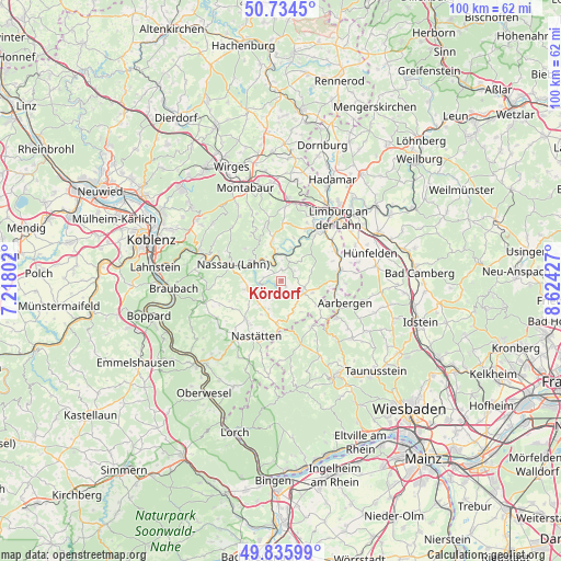
Kördorf GPS coordinates[2]
50° 17' 14.532" North, 7° 55' 16.104" East
| Map corner | latitude | longitude |
|---|---|---|
| Upper-left | 50.7345°, | 7.21802° |
| Center: | 50.28737°, | 7.92114° |
| Lower-right: | 49.83599°, | 8.62427° |
| Map W x H: | 99.9×99.9 km | = 62.1×62.1mi |
| max Lat: | 55.01917° ⇑57% North |
| Kördorf: | 50.28737° |
| min Lat: | ⇓43% South 47.40724° |
| min Long | Kördorf | max Long |
| 5.92978° | 7.92114° | 14.98853° |
| W 21.4%⇐ | ⇒78.6% E |
Elevation
Elevation of Kördorf is 324 m = 1063 ft, and this is 74.9 m = 246 ft above average elevation for this country.
| Max E: |
1256 m = 4121 ft | 34.6% |
| Kördorf | 324 m 1063 ft | |
| Avg. | 249.1 m = 817 ft | |
Min E: |
-5 m = -16 ft | 65.4% |
See also: Germany elevation on elevation.city.
Geographical zone
Kördorf is located in North temperate zone (between Tropic of Cancer and the Arctic Circle). Distance of this North polar circle is 1809.7 km =1124.5 mi to North.| Distance of | km | miles | from Kördorf |
|---|---|---|---|
| North Pole | 4415.6 | 2743.7 | to North |
| Arctic Circle | 1809.7 | 1124.5 | to North |
| Tropic Cancer | 2985.5 | 1855.1 | to South |
| Equator | 5591.4 | 3474.3 | to South |


Nearby cities:
15 places around Kördorf: (largest is in red/bold)
• Attenhausen
3.3 km =2.1 mi,  278°
278°
• Biebrich
2.8 km =1.7 mi,  48°
48°
• Bremberg
2.1 km =1.3 mi,  358°
358°
• Dörnberg
5 km =3.1 mi,  327°
327°
• Ebertshausen
4.4 km =2.7 mi,  95°
95°
• Ergeshausen
2.3 km =1.4 mi,  138°
138°
• Gutenacker
3.6 km =2.2 mi,  1°
1°
• Herold
1.3 km =0.8 mi,  145°
145°
• Katzenelnbogen
4.3 km =2.7 mi,  120°
120°
• Klingelbach
3.7 km =2.3 mi,  110°
110°
• Mittelfischbach
4.7 km =2.9 mi, 142°
• Niedertiefenbach
3.9 km =2.4 mi,  205°
205°
• Oberfischbach
4.9 km =3 mi, 150°
• Roth
2.9 km =1.8 mi,  217°
217°
• Wasenbach
4.6 km =2.9 mi,  44°
44°
Sources, notices
• [Note1] Compared only with cities in Germany existing in our database
• [Src1] Map data: © OpenStreetMap contributors (CC-BY-SA)
• [Src2] Other city data from geonames.org with taken over terms of usage.
• [Src3] Geographical zone / Annual Mean Temperature by Robert A. Rohde @ Wikipedia
