Wapelfeld geodata
Wapelfeld (Schleswig-Holstein) is a seat of a fourth-order administrative division; located in Germany in Europe/Berlin (GMT+2) time zone. With population of 335 people, there are 9924 cities with bigger population in this country. Compared to other cities in Germany, 93.7% of cities are located further ↓South; 56.2% of cities are located further →East and 93.9% of cities have higher elevation than Wapelfeld. Note1
Administrative division(s):
- Level 1: Schleswig-Holstein
- Level 3: Kreis Rendsburg-Eckernförde
- Level 4: Wapelfeld


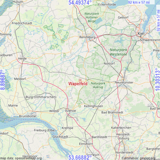
Wapelfeld GPS coordinates[2]
54° 4' 59.988" North, 9° 36' 0" East
| Map corner | latitude | longitude |
|---|---|---|
| Upper-left | 54.49374°, | 8.89687° |
| Center: | 54.08333°, | 9.6° |
| Lower-right: | 53.66882°, | 10.30313° |
| Map W x H: | 91.7×91.7 km | = 57×57mi |
| max Lat: | 55.01917° ⇑6.3% North |
| Wapelfeld: | 54.08333° |
| min Lat: | ⇓93.7% South 47.40724° |
| min Long | Wapelfeld | max Long |
| 5.92978° | 9.6° | 14.98853° |
| W 43.8%⇐ | ⇒56.2% E |
Elevation
Elevation of Wapelfeld is 11 m = 36 ft, and this is 238.1 m = 781 ft below average elevation for this country.
| Max E: |
1256 m = 4121 ft | 93.9% |
| Avg. | 249.1 m = 817 ft | |
| Wapelfeld | 11 m = 36 ft | |
Min E: |
-5 m = -16 ft | 6.1% |
See also: Germany elevation on elevation.city.
Geographical zone
Wapelfeld is located in North temperate zone (between Tropic of Cancer and the Arctic Circle). Distance of this North polar circle is 1387.7 km =862.3 mi to North.| Distance of | km | miles | from Wapelfeld |
|---|---|---|---|
| North Pole | 3993.6 | 2481.5 | to North |
| Arctic Circle | 1387.7 | 862.3 | to North |
| Tropic Cancer | 3407.6 | 2117.4 | to South |
| Equator | 6013.5 | 3736.6 | to South |


Nearby cities:
15 places around Wapelfeld: (largest is in red/bold)
• Beringstedt
5.7 km =3.5 mi,  310°
310°
• Christinenthal
5.7 km =3.5 mi,  229°
229°
• Dörpstedt
4.9 km =3 mi,  352°
352°
• Grauel
4.7 km =2.9 mi,  113°
113°
• Hohenwestedt
3.5 km =2.2 mi,  80°
80°
• Jahrsdorf
2.9 km =1.8 mi,  130°
130°
• Nienborstel
5.7 km =3.5 mi,  11°
11°
• Oldenborstel
5.7 km =3.5 mi,  251°
251°
• Osterstedt
3.2 km =2 mi,  328°
328°
• Peissen
6.4 km =4 mi,  175°
175°
• Puls
5.4 km =3.4 mi,  270°
270°
• Reher
2.1 km =1.3 mi,  210°
210°
• Remmels
4.9 km =3 mi,  41°
41°
• Silzen
5.7 km =3.5 mi,  168°
168°
• Todenbüttel
6.4 km =4 mi, 329°
Sources, notices
• [Note1] Compared only with cities in Germany existing in our database
• [Src1] Map data: © OpenStreetMap contributors (CC-BY-SA)
• [Src2] Other city data from geonames.org with taken over terms of usage.
• [Src3] Geographical zone / Annual Mean Temperature by Robert A. Rohde @ Wikipedia
