Reher geodata
Reher (Schleswig-Holstein) is a seat of a fourth-order administrative division; located in Germany in Europe/Berlin (GMT+2) time zone. With population of 816 people, there are 7839 cities with bigger population in this country. Compared to other cities in Germany, 93.4% of cities are located further ↓South; 56.5% of cities are located further →East and 88.3% of cities have higher elevation than Reher. Note1


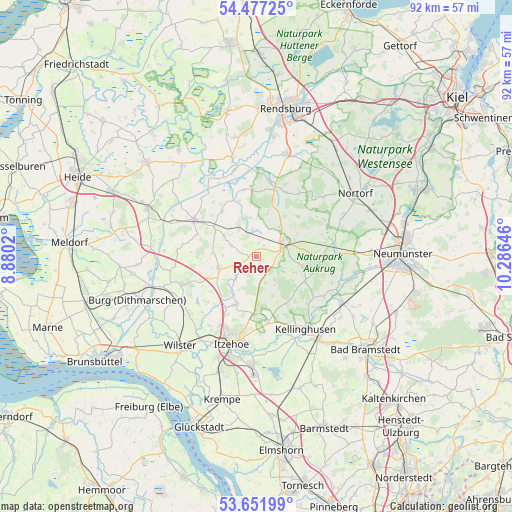
Reher GPS coordinates[2]
54° 4' 0.012" North, 9° 34' 59.988" East
| Map corner | latitude | longitude |
|---|---|---|
| Upper-left | 54.47725°, | 8.8802° |
| Center: | 54.06667°, | 9.58333° |
| Lower-right: | 53.65199°, | 10.28646° |
| Map W x H: | 91.8×91.8 km | = 57×57mi |
| max Lat: | 55.01917° ⇑6.6% North |
| Reher: | 54.06667° |
| min Lat: | ⇓93.4% South 47.40724° |
| min Long | Reher | max Long |
| 5.92978° | 9.58333° | 14.98853° |
| W 43.5%⇐ | ⇒56.5% E |
Elevation
Elevation of Reher is 26 m = 85 ft, and this is 223.1 m = 732 ft below average elevation for this country.
| Max E: |
1256 m = 4121 ft | 88.3% |
| Avg. | 249.1 m = 817 ft | |
| Reher | 26 m = 85 ft | |
Min E: |
-5 m = -16 ft | 11.7% |
See also: Germany elevation on elevation.city.
Geographical zone
Reher is located in North temperate zone (between Tropic of Cancer and the Arctic Circle). Distance of this North polar circle is 1389.5 km =863.4 mi to North.| Distance of | km | miles | from Reher |
|---|---|---|---|
| North Pole | 3995.4 | 2482.6 | to North |
| Arctic Circle | 1389.5 | 863.4 | to North |
| Tropic Cancer | 3405.7 | 2116.2 | to South |
| Equator | 6011.7 | 3735.5 | to South |


Nearby cities:
15 places around Reher: (largest is in red/bold)
• Beringstedt
6.4 km =4 mi,  329°
329°
• Christinenthal
3.8 km =2.4 mi,  240°
240°
• Dörpstedt
6.7 km =4.2 mi,  3°
3°
• Grauel
5.4 km =3.4 mi,  90°
90°
• Hohenwestedt
5.2 km =3.2 mi,  61°
61°
• Jahrsdorf
3.3 km =2.1 mi, 90°
• Looft
5.7 km =3.5 mi,  222°
222°
• Oldenborstel
4.3 km =2.7 mi,  270°
270°
• Osterstedt
4.7 km =2.9 mi,  352°
352°
• Peissen
4.8 km =3 mi,  160°
160°
• Puls
4.7 km =2.9 mi,  293°
293°
• Schenefeld
6.8 km =4.2 mi,  254°
254°
• Seefeld
6.9 km =4.3 mi,  302°
302°
• Silzen
4.3 km =2.7 mi,  149°
149°
• Wapelfeld
2.1 km =1.3 mi,  30°
30°
Sources, notices
• [Note1] Compared only with cities in Germany existing in our database
• [Src1] Map data: © OpenStreetMap contributors (CC-BY-SA)
• [Src2] Other city data from geonames.org with taken over terms of usage.
• [Src3] Geographical zone / Annual Mean Temperature by Robert A. Rohde @ Wikipedia
