Waldbröl geodata
Waldbröl (North Rhine-Westphalia) is a populated place; located in Germany in Europe/Berlin (GMT+2) time zone. With population of 19,533 people, there are 793 cities with bigger population in this country. Compared to other cities in Germany, 55.6% of cities are located further ↓South; 84.6% of cities are located further →East and 57.9% of cities have lower elevation than Waldbröl. Note1
Administrative division(s):
- Level 1: North Rhine-Westphalia
- Level 2: Regierungsbezirk Köln
- Level 3: Oberbergischer Kreis
- Level 4: Waldbröl


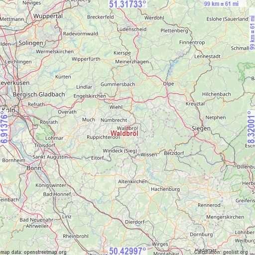
Waldbröl GPS coordinates[2]
50° 52' 32.736" North, 7° 37' 0.768" East
| Map corner | latitude | longitude |
|---|---|---|
| Upper-left | 51.31733°, | 6.91376° |
| Center: | 50.87576°, | 7.61688° |
| Lower-right: | 50.42997°, | 8.32001° |
| Map W x H: | 98.7×98.7 km | = 61.3×61.3mi |
| max Lat: | 55.01917° ⇑44.4% North |
| Waldbröl: | 50.87576° |
| min Lat: | ⇓55.6% South 47.40724° |
| min Long | Waldbröl | max Long |
| 5.92978° | 7.61688° | 14.98853° |
| W 15.4%⇐ | ⇒84.6% E |
Elevation
Elevation of Waldbröl is 278 m = 912 ft, and this is 28.9 m = 95 ft above average elevation for this country.
| Max E: |
1256 m = 4121 ft | 42.1% |
| Waldbröl | 278 m 912 ft | |
| Avg. | 249.1 m = 817 ft | |
Min E: |
-5 m = -16 ft | 57.9% |
See also: Germany elevation on elevation.city.
Geographical zone
Waldbröl is located in North temperate zone (between Tropic of Cancer and the Arctic Circle). Distance of this North polar circle is 1744.3 km =1083.9 mi to North.| Distance of | km | miles | from Waldbröl |
|---|---|---|---|
| North Pole | 4350.2 | 2703.1 | to North |
| Arctic Circle | 1744.3 | 1083.9 | to North |
| Tropic Cancer | 3050.9 | 1895.7 | to South |
| Equator | 5656.9 | 3515 | to South |


Nearby cities:
15 places around Waldbröl: (largest is in red/bold)
• Birken-Honigsessen
10.5 km =6.5 mi,  128°
128°
• Bitzen
9.6 km =6 mi,  151°
151°
• Etzbach
11.9 km =7.4 mi,  155°
155°
• Forst
9.6 km =6 mi, 151°
• Friesenhagen
13.9 km =8.6 mi,  77°
77°
• Fürthen
10.9 km =6.8 mi, 161°
• Hamm
13 km =8.1 mi, 160°
• Morsbach
7.9 km =4.9 mi,  97°
97°
• Niederirsen
14 km =8.7 mi,  184°
184°
• Nümbrecht
6.2 km =3.9 mi,  300°
300°
• Pracht
13 km =8.1 mi,  170°
170°
• Roth
13.9 km =8.6 mi, 155°
• Ruppichteroth
10 km =6.2 mi,  249°
249°
• Wiehl
9.4 km =5.8 mi,  330°
330°
• Wissen
13.6 km =8.5 mi,  142°
142°
Sources, notices
• [Note1] Compared only with cities in Germany existing in our database
• [Src1] Map data: © OpenStreetMap contributors (CC-BY-SA)
• [Src2] Other city data from geonames.org with taken over terms of usage.
• [Src3] Geographical zone / Annual Mean Temperature by Robert A. Rohde @ Wikipedia
