Wiehl geodata
Wiehl (North Rhine-Westphalia) is a populated place; located in Germany in Europe/Berlin (GMT+2) time zone. With population of 26,291 people, there are 552 cities with bigger population in this country. Compared to other cities in Germany, 57.1% of cities are located further ↓South; 85.9% of cities are located further →East and 54% of cities have higher elevation than Wiehl. Note1
Administrative division(s):
- Level 1: North Rhine-Westphalia
- Level 2: Regierungsbezirk Köln
- Level 3: Oberbergischer Kreis
- Level 4: Wiehl


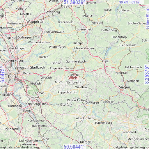
Wiehl GPS coordinates[2]
50° 56' 58.2" North, 7° 33' 2.232" East
| Map corner | latitude | longitude |
|---|---|---|
| Upper-left | 51.39036°, | 6.8475° |
| Center: | 50.9495°, | 7.55062° |
| Lower-right: | 50.50441°, | 8.25375° |
| Map W x H: | 98.5×98.5 km | = 61.2×61.2mi |
| max Lat: | 55.01917° ⇑42.9% North |
| Wiehl: | 50.9495° |
| min Lat: | ⇓57.1% South 47.40724° |
| min Long | Wiehl | max Long |
| 5.92978° | 7.55062° | 14.98853° |
| W 14.1%⇐ | ⇒85.9% E |
Elevation
Elevation of Wiehl is 197 m = 646 ft, and this is 52.1 m = 171 ft below average elevation for this country.
| Max E: |
1256 m = 4121 ft | 54% |
| Avg. | 249.1 m = 817 ft | |
| Wiehl | 197 m = 646 ft | |
Min E: |
-5 m = -16 ft | 46% |
See also: Germany elevation on elevation.city.
Geographical zone
Wiehl is located in North temperate zone (between Tropic of Cancer and the Arctic Circle). Distance of this North polar circle is 1736.1 km =1078.8 mi to North.| Distance of | km | miles | from Wiehl |
|---|---|---|---|
| North Pole | 4342 | 2698 | to North |
| Arctic Circle | 1736.1 | 1078.8 | to North |
| Tropic Cancer | 3059.1 | 1900.8 | to South |
| Equator | 5665.1 | 3520.1 | to South |


Nearby cities:
15 places around Wiehl: (largest is in red/bold)
• Bergneustadt
11.2 km =7 mi,  41°
41°
• Drolshagen
17.6 km =10.9 mi,  62°
62°
• Engelskirchen
10.5 km =6.5 mi,  294°
294°
• Forst
19.1 km =11.9 mi,  150°
150°
• Friesenhagen
18.8 km =11.7 mi,  105°
105°
• Gummersbach
8.6 km =5.3 mi,  6°
6°
• Lindlar
14.4 km =8.9 mi,  302°
302°
• Marienheide
14.9 km =9.3 mi,  354°
354°
• Meinerzhagen
18.8 km =11.7 mi,  21°
21°
• Morsbach
15.5 km =9.6 mi,  126°
126°
• Much
11.5 km =7.1 mi,  243°
243°
• Nümbrecht
5.1 km =3.2 mi,  187°
187°
• Overath
18.8 km =11.7 mi,  264°
264°
• Ruppichteroth
12.7 km =7.9 mi,  201°
201°
• Waldbröl
9.4 km =5.8 mi, 150°
Sources, notices
• [Note1] Compared only with cities in Germany existing in our database
• [Src1] Map data: © OpenStreetMap contributors (CC-BY-SA)
• [Src2] Other city data from geonames.org with taken over terms of usage.
• [Src3] Geographical zone / Annual Mean Temperature by Robert A. Rohde @ Wikipedia
