Waakirchen geodata
Waakirchen (Bavaria) is a seat of a fourth-order administrative division; located in Germany in Europe/Berlin (GMT+2) time zone. With population of 5,464 people, there are 2644 cities with bigger population in this country. Compared to other cities in Germany, 98% of cities are located further ↑North; 76.8% of cities are located further ←West and 98.9% of cities have lower elevation than Waakirchen. Note1
Administrative division(s):
- Level 1: Bavaria
- Level 2: Upper Bavaria
- Level 3: Landkreis Miesbach
- Level 4: Waakirchen


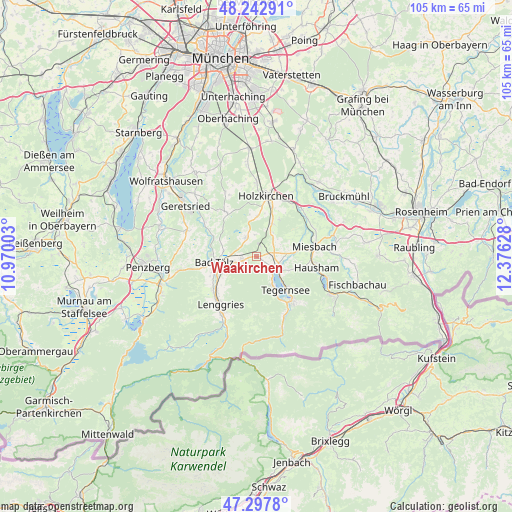
Waakirchen GPS coordinates[2]
47° 46' 21" North, 11° 40' 23.34" East
| Map corner | latitude | longitude |
|---|---|---|
| Upper-left | 48.24291°, | 10.97003° |
| Center: | 47.7725°, | 11.67315° |
| Lower-right: | 47.2978°, | 12.37628° |
| Map W x H: | 105.1×105.1 km | = 65.3×65.3mi |
| max Lat: | 55.01917° ⇑98% North |
| Waakirchen: | 47.7725° |
| min Lat: | ⇓2% South 47.40724° |
| min Long | Waakirchen | max Long |
| 5.92978° | 11.67315° | 14.98853° |
| W 76.8%⇐ | ⇒23.2% E |
Elevation
Elevation of Waakirchen is 767 m = 2516 ft, and this is 517.9 m = 1699 ft above average elevation for this country.
| Max E: |
1256 m = 4121 ft | 1.1% |
| Waakirchen | 767 m 2516 ft | |
| Avg. | 249.1 m = 817 ft | |
Min E: |
-5 m = -16 ft | 98.9% |
See also: Germany elevation on elevation.city.
Geographical zone
Waakirchen is located in North temperate zone (between Tropic of Cancer and the Arctic Circle). Distance of this North polar circle is 2089.4 km =1298.3 mi to North.| Distance of | km | miles | from Waakirchen |
|---|---|---|---|
| North Pole | 4695.3 | 2917.5 | to North |
| Arctic Circle | 2089.4 | 1298.3 | to North |
| Tropic Cancer | 2705.9 | 1681.4 | to South |
| Equator | 5311.8 | 3300.6 | to South |


Nearby cities:
15 places around Waakirchen: (largest is in red/bold)
• Bad Tölz
8.6 km =5.3 mi,  261°
261°
• Bad Wiessee
7 km =4.3 mi,  152°
152°
• Dietramszell
10.3 km =6.4 mi,  325°
325°
• Gaißach
7.2 km =4.5 mi,  249°
249°
• Gmund am Tegernsee
5.4 km =3.4 mi,  116°
116°
• Greiling
4.3 km =2.7 mi, 261°
• Holzkirchen
11.8 km =7.3 mi,  10°
10°
• Lenggries
12.7 km =7.9 mi,  218°
218°
• Miesbach
12.1 km =7.5 mi,  81°
81°
• Reichersbeuern
3 km =1.9 mi, 257°
• Rottach-Egern
11.7 km =7.3 mi,  141°
141°
• Sachsenkam
4.3 km =2.7 mi, 329°
• Tegernsee
9.2 km =5.7 mi, 136°
• Wackersberg
10.2 km =6.3 mi,  244°
244°
• Warngau
7.6 km =4.7 mi,  28°
28°
Sources, notices
• [Note1] Compared only with cities in Germany existing in our database
• [Src1] Map data: © OpenStreetMap contributors (CC-BY-SA)
• [Src2] Other city data from geonames.org with taken over terms of usage.
• [Src3] Geographical zone / Annual Mean Temperature by Robert A. Rohde @ Wikipedia
