Bad Wiessee geodata
Bad Wiessee (Bavaria) is a seat of a fourth-order administrative division; located in Germany in Europe/Berlin (GMT+2) time zone. With population of 4,293 people, there are 3134 cities with bigger population in this country. Compared to other cities in Germany, 98.6% of cities are located further ↑North; 77.4% of cities are located further ←West and 98.7% of cities have lower elevation than Bad Wiessee. Note1
Administrative division(s):
- Level 1: Bavaria
- Level 2: Upper Bavaria
- Level 3: Landkreis Miesbach
- Level 4: Bad Wiessee


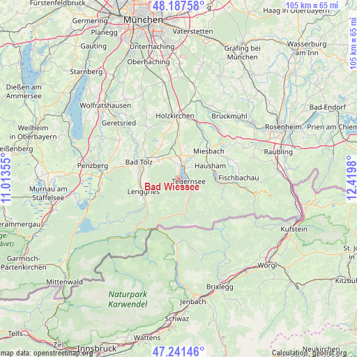
Bad Wiessee GPS coordinates[2]
47° 43' 0.012" North, 11° 43' 0.012" East
| Map corner | latitude | longitude |
|---|---|---|
| Upper-left | 48.18758°, | 11.01355° |
| Center: | 47.71667°, | 11.71667° |
| Lower-right: | 47.24146°, | 12.4198° |
| Map W x H: | 105.2×105.2 km | = 65.4×65.4mi |
| max Lat: | 55.01917° ⇑98.6% North |
| Bad Wiessee: | 47.71667° |
| min Lat: | ⇓1.4% South 47.40724° |
| min Long | Bad Wiessee | max Long |
| 5.92978° | 11.71667° | 14.98853° |
| W 77.4%⇐ | ⇒22.6% E |
Elevation
Elevation of Bad Wiessee is 751 m = 2464 ft, and this is 501.9 m = 1647 ft above average elevation for this country.
| Max E: |
1256 m = 4121 ft | 1.3% |
| Bad Wiessee | 751 m 2464 ft | |
| Avg. | 249.1 m = 817 ft | |
Min E: |
-5 m = -16 ft | 98.7% |
See also: Germany elevation on elevation.city.
Geographical zone
Bad Wiessee is located in North temperate zone (between Tropic of Cancer and the Arctic Circle). Distance of this North polar circle is 2095.6 km =1302.1 mi to North.| Distance of | km | miles | from Bad Wiessee |
|---|---|---|---|
| North Pole | 4701.5 | 2921.4 | to North |
| Arctic Circle | 2095.6 | 1302.1 | to North |
| Tropic Cancer | 2699.7 | 1677.5 | to South |
| Equator | 5305.6 | 3296.7 | to South |


Nearby cities:
15 places around Bad Wiessee: (largest is in red/bold)
• Gaißach
10.6 km =6.6 mi,  290°
290°
• Gmund am Tegernsee
4.2 km =2.6 mi,  22°
22°
• Greiling
9.3 km =5.8 mi,  306°
306°
• Hausham
9.9 km =6.2 mi,  70°
70°
• Kreuth
8.7 km =5.4 mi,  165°
165°
• Lenggries
11.8 km =7.3 mi,  251°
251°
• Miesbach
11.9 km =7.4 mi,  47°
47°
• Reichersbeuern
8.4 km =5.2 mi, 311°
• Rottach-Egern
5 km =3.1 mi,  126°
126°
• Sachsenkam
11.3 km =7 mi,  331°
331°
• Schliersee
10.9 km =6.8 mi,  78°
78°
• Tegernsee
3.1 km =1.9 mi,  98°
98°
• Waakirchen
7 km =4.3 mi, 332°
• Wackersberg
12.6 km =7.8 mi,  278°
278°
• Warngau
12.8 km =8 mi,  1°
1°
Sources, notices
• [Note1] Compared only with cities in Germany existing in our database
• [Src1] Map data: © OpenStreetMap contributors (CC-BY-SA)
• [Src2] Other city data from geonames.org with taken over terms of usage.
• [Src3] Geographical zone / Annual Mean Temperature by Robert A. Rohde @ Wikipedia
