Gmund am Tegernsee geodata
Gmund am Tegernsee (Bavaria) is a populated place; located in Germany in Europe/Berlin (GMT+2) time zone. With population of 6,086 people, there are 2434 cities with bigger population in this country. Compared to other cities in Germany, 98.2% of cities are located further ↑North; 77.8% of cities are located further ←West and 98.6% of cities have lower elevation than Gmund am Tegernsee. Note1
Administrative division(s):
- Level 1: Bavaria
- Level 2: Upper Bavaria
- Level 3: Landkreis Miesbach
- Level 4: Gmund a.Tegernsee


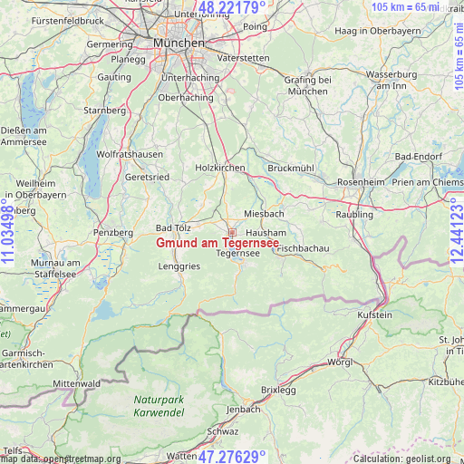
Gmund am Tegernsee GPS coordinates[2]
47° 45' 4.284" North, 11° 44' 17.16" East
| Map corner | latitude | longitude |
|---|---|---|
| Upper-left | 48.22179°, | 11.03498° |
| Center: | 47.75119°, | 11.7381° |
| Lower-right: | 47.27629°, | 12.44123° |
| Map W x H: | 105.1×105.1 km | = 65.3×65.3mi |
| max Lat: | 55.01917° ⇑98.2% North |
| Gmund am Tegernsee: | 47.75119° |
| min Lat: | ⇓1.8% South 47.40724° |
| min Long | Gmund am Tegern | max Long |
| 5.92978° | 11.7381° | 14.98853° |
| W 77.8%⇐ | ⇒22.2% E |
Elevation
Elevation of Gmund am Tegernsee is 739 m = 2425 ft, and this is 489.9 m = 1607 ft above average elevation for this country.
| Max E: |
1256 m = 4121 ft | 1.4% |
| Gmund am Tegernsee | 739 m 2425 ft | |
| Avg. | 249.1 m = 817 ft | |
Min E: |
-5 m = -16 ft | 98.6% |
See also: Germany elevation on elevation.city.
Geographical zone
Gmund am Tegernsee is located in North temperate zone (between Tropic of Cancer and the Arctic Circle). Distance of this North polar circle is 2091.7 km =1299.7 mi to North.| Distance of | km | miles | from Gmund am Tegernsee |
|---|---|---|---|
| North Pole | 4697.6 | 2919 | to North |
| Arctic Circle | 2091.7 | 1299.7 | to North |
| Tropic Cancer | 2703.5 | 1679.9 | to South |
| Equator | 5309.4 | 3299.1 | to South |


Nearby cities:
15 places around Gmund am Tegernsee: (largest is in red/bold)
• Bad Tölz
13.4 km =8.3 mi,  274°
274°
• Bad Wiessee
4.2 km =2.6 mi,  202°
202°
• Gaißach
11.6 km =7.2 mi, 269°
• Greiling
9.2 km =5.7 mi,  280°
280°
• Hausham
7.7 km =4.8 mi,  93°
93°
• Kreuth
12.3 km =7.6 mi,  177°
177°
• Miesbach
8.3 km =5.2 mi,  59°
59°
• Reichersbeuern
8 km =5 mi, 282°
• Rottach-Egern
7.3 km =4.5 mi,  160°
160°
• Sachsenkam
9.3 km =5.8 mi,  310°
310°
• Schliersee
9.2 km =5.7 mi,  100°
100°
• Tegernsee
4.6 km =2.9 mi, 160°
• Waakirchen
5.4 km =3.4 mi,  296°
296°
• Warngau
9.1 km =5.7 mi,  352°
352°
• Weyarn
12.8 km =8 mi,  20°
20°
Sources, notices
• [Note1] Compared only with cities in Germany existing in our database
• [Src1] Map data: © OpenStreetMap contributors (CC-BY-SA)
• [Src2] Other city data from geonames.org with taken over terms of usage.
• [Src3] Geographical zone / Annual Mean Temperature by Robert A. Rohde @ Wikipedia
