Vögelsen geodata
Vögelsen (Lower Saxony) is a seat of a fourth-order administrative division; located in Germany in Europe/Berlin (GMT+2) time zone. With population of 2,299 people, there are 4672 cities with bigger population in this country. Compared to other cities in Germany, 83.4% of cities are located further ↓South; 56.4% of cities are located further ←West and 85.8% of cities have higher elevation than Vögelsen. Note1


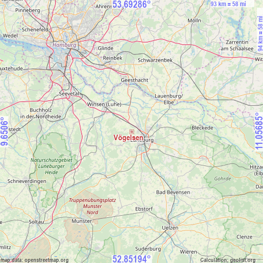
Vögelsen GPS coordinates[2]
53° 16' 28.092" North, 10° 21' 13.392" East
| Map corner | latitude | longitude |
|---|---|---|
| Upper-left | 53.69286°, | 9.6506° |
| Center: | 53.27447°, | 10.35372° |
| Lower-right: | 52.85194°, | 11.05685° |
| Map W x H: | 93.5×93.5 km | = 58.1×58.1mi |
| max Lat: | 55.01917° ⇑16.6% North |
| Vögelsen: | 53.27447° |
| min Lat: | ⇓83.4% South 47.40724° |
| min Long | Vögelsen | max Long |
| 5.92978° | 10.35372° | 14.98853° |
| W 56.4%⇐ | ⇒43.6% E |
Elevation
Elevation of Vögelsen is 33 m = 108 ft, and this is 216.1 m = 709 ft below average elevation for this country.
| Max E: |
1256 m = 4121 ft | 85.8% |
| Avg. | 249.1 m = 817 ft | |
| Vögelsen | 33 m = 108 ft | |
Min E: |
-5 m = -16 ft | 14.2% |
See also: Germany elevation on elevation.city.
Geographical zone
Vögelsen is located in North temperate zone (between Tropic of Cancer and the Arctic Circle). Distance of this North polar circle is 1477.6 km =918.1 mi to North.| Distance of | km | miles | from Vögelsen |
|---|---|---|---|
| North Pole | 4083.5 | 2537.4 | to North |
| Arctic Circle | 1477.6 | 918.1 | to North |
| Tropic Cancer | 3317.6 | 2061.5 | to South |
| Equator | 5923.6 | 3680.8 | to South |


Nearby cities:
15 places around Vögelsen: (largest is in red/bold)
• Adendorf
5.7 km =3.5 mi,  81°
81°
• Bardowick
3.1 km =1.9 mi,  47°
47°
• Barum
8.9 km =5.5 mi,  20°
20°
• Brietlingen
9.2 km =5.7 mi,  44°
44°
• Deutsch Evern
9.8 km =6.1 mi,  147°
147°
• Handorf
7.4 km =4.6 mi,  356°
356°
• Kirchgellersen
5.8 km =3.6 mi,  217°
217°
• Lüneburg
4.8 km =3 mi,  123°
123°
• Mechtersen
2.7 km =1.7 mi,  291°
291°
• Radbruch
6.6 km =4.1 mi,  315°
315°
• Reppenstedt
2.7 km =1.7 mi,  185°
185°
• Südergellersen
7.4 km =4.6 mi,  209°
209°
• Vierhöfen
9.2 km =5.7 mi,  264°
264°
• Westergellersen
8.3 km =5.2 mi,  236°
236°
• Wittorf
6.8 km =4.2 mi, 16°
Sources, notices
• [Note1] Compared only with cities in Germany existing in our database
• [Src1] Map data: © OpenStreetMap contributors (CC-BY-SA)
• [Src2] Other city data from geonames.org with taken over terms of usage.
• [Src3] Geographical zone / Annual Mean Temperature by Robert A. Rohde @ Wikipedia
