Brietlingen geodata
Brietlingen (Lower Saxony) is a seat of a fourth-order administrative division; located in Germany in Europe/Berlin (GMT+2) time zone. With population of 3,150 people, there are 3872 cities with bigger population in this country. Compared to other cities in Germany, 83.9% of cities are located further ↓South; 58% of cities are located further ←West and 96.6% of cities have higher elevation than Brietlingen. Note1


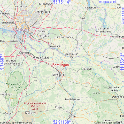
Brietlingen GPS coordinates[2]
53° 19' 59.988" North, 10° 27' 0" East
| Map corner | latitude | longitude |
|---|---|---|
| Upper-left | 53.75114°, | 9.74687° |
| Center: | 53.33333°, | 10.45° |
| Lower-right: | 52.91138°, | 11.15313° |
| Map W x H: | 93.4×93.4 km | = 58×58mi |
| max Lat: | 55.01917° ⇑16.1% North |
| Brietlingen: | 53.33333° |
| min Lat: | ⇓83.9% South 47.40724° |
| min Long | Brietlingen | max Long |
| 5.92978° | 10.45° | 14.98853° |
| W 58%⇐ | ⇒42% E |
Elevation
Elevation of Brietlingen is 5 m = 16 ft, and this is 244.1 m = 801 ft below average elevation for this country.
| Max E: |
1256 m = 4121 ft | 96.6% |
| Avg. | 249.1 m = 817 ft | |
| Brietlingen | 5 m = 16 ft | |
Min E: |
-5 m = -16 ft | 3.4% |
See also: Germany elevation on elevation.city.
Geographical zone
Brietlingen is located in North temperate zone (between Tropic of Cancer and the Arctic Circle). Distance of this North polar circle is 1471.1 km =914.1 mi to North.| Distance of | km | miles | from Brietlingen |
|---|---|---|---|
| North Pole | 4077 | 2533.3 | to North |
| Arctic Circle | 1471.1 | 914.1 | to North |
| Tropic Cancer | 3324.2 | 2065.6 | to South |
| Equator | 5930.1 | 3684.8 | to South |


Nearby cities:
15 places around Brietlingen: (largest is in red/bold)
• Adendorf
5.8 km =3.6 mi,  188°
188°
• Artlenburg
5 km =3.1 mi,  30°
30°
• Bardowick
6 km =3.7 mi,  222°
222°
• Barum
3.8 km =2.4 mi,  299°
299°
• Echem
5.5 km =3.4 mi,  90°
90°
• Handorf
6.9 km =4.3 mi,  276°
276°
• Krüzen
9.2 km =5.7 mi,  36°
36°
• Lauenburg
8.3 km =5.2 mi,  58°
58°
• Lüdersburg
8.4 km =5.2 mi,  99°
99°
• Rullstorf
7.4 km =4.6 mi,  134°
134°
• Scharnebeck
5.7 km =3.5 mi,  142°
142°
• Schnakenbek
6.5 km =4 mi, 30°
• Tespe
7.5 km =4.7 mi,  339°
339°
• Vögelsen
9.2 km =5.7 mi, 224°
• Wittorf
4.4 km =2.7 mi,  270°
270°
Sources, notices
• [Note1] Compared only with cities in Germany existing in our database
• [Src1] Map data: © OpenStreetMap contributors (CC-BY-SA)
• [Src2] Other city data from geonames.org with taken over terms of usage.
• [Src3] Geographical zone / Annual Mean Temperature by Robert A. Rohde @ Wikipedia
