Adendorf geodata
Adendorf (Lower Saxony) is a seat of a fourth-order administrative division; located in Germany in Europe/Berlin (GMT+2) time zone. With population of 9,865 people, there are 1649 cities with bigger population in this country. Compared to other cities in Germany, 83.5% of cities are located further ↓South; 57.9% of cities are located further ←West and 87.7% of cities have higher elevation than Adendorf. Note1


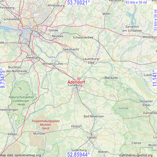
Adendorf GPS coordinates[2]
53° 16' 54.804" North, 10° 26' 16.332" East
| Map corner | latitude | longitude |
|---|---|---|
| Upper-left | 53.70021°, | 9.73475° |
| Center: | 53.28189°, | 10.43787° |
| Lower-right: | 52.85944°, | 11.141° |
| Map W x H: | 93.5×93.5 km | = 58.1×58.1mi |
| max Lat: | 55.01917° ⇑16.5% North |
| Adendorf: | 53.28189° |
| min Lat: | ⇓83.5% South 47.40724° |
| min Long | Adendorf | max Long |
| 5.92978° | 10.43787° | 14.98853° |
| W 57.9%⇐ | ⇒42.1% E |
Elevation
Elevation of Adendorf is 28 m = 92 ft, and this is 221.1 m = 725 ft below average elevation for this country.
| Max E: |
1256 m = 4121 ft | 87.7% |
| Avg. | 249.1 m = 817 ft | |
| Adendorf | 28 m = 92 ft | |
Min E: |
-5 m = -16 ft | 12.3% |
See also: Germany elevation on elevation.city.
Geographical zone
Adendorf is located in North temperate zone (between Tropic of Cancer and the Arctic Circle). Distance of this North polar circle is 1476.8 km =917.6 mi to North.| Distance of | km | miles | from Adendorf |
|---|---|---|---|
| North Pole | 4082.7 | 2536.9 | to North |
| Arctic Circle | 1476.8 | 917.6 | to North |
| Tropic Cancer | 3318.5 | 2062 | to South |
| Equator | 5924.4 | 3681.3 | to South |


Nearby cities:
15 places around Adendorf: (largest is in red/bold)
• Bardowick
3.6 km =2.2 mi,  291°
291°
• Barendorf
8.1 km =5 mi,  136°
136°
• Barum
8 km =5 mi,  341°
341°
• Brietlingen
5.8 km =3.6 mi,  8°
8°
• Deutsch Evern
9.1 km =5.7 mi,  181°
181°
• Echem
8.5 km =5.3 mi,  47°
47°
• Handorf
8.9 km =5.5 mi,  317°
317°
• Lüneburg
3.8 km =2.4 mi,  204°
204°
• Mechtersen
8.1 km =5 mi,  271°
271°
• Reppenstedt
6.8 km =4.2 mi,  238°
238°
• Rullstorf
6.1 km =3.8 mi,  85°
85°
• Scharnebeck
4.4 km =2.7 mi,  74°
74°
• Vögelsen
5.7 km =3.5 mi,  261°
261°
• Wendisch Evern
7.5 km =4.7 mi,  165°
165°
• Wittorf
6.8 km =4.2 mi,  327°
327°
Sources, notices
• [Note1] Compared only with cities in Germany existing in our database
• [Src1] Map data: © OpenStreetMap contributors (CC-BY-SA)
• [Src2] Other city data from geonames.org with taken over terms of usage.
• [Src3] Geographical zone / Annual Mean Temperature by Robert A. Rohde @ Wikipedia
