Kölleda geodata
Kölleda (Thuringia) is a populated place; located in Germany in Europe/Berlin (GMT+2) time zone. With population of 5,824 people, there are 2520 cities with bigger population in this country. Compared to other cities in Germany, 61.3% of cities are located further ↓South; 70.6% of cities are located further ←West and 60.9% of cities have higher elevation than Kölleda. Note1


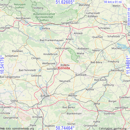
Kölleda GPS coordinates[2]
51° 11' 14.82" North, 11° 14' 41.568" East
| Map corner | latitude | longitude |
|---|---|---|
| Upper-left | 51.62605°, | 10.54176° |
| Center: | 51.18745°, | 11.24488° |
| Lower-right: | 50.74464°, | 11.94801° |
| Map W x H: | 98×98 km | = 60.9×60.9mi |
| max Lat: | 55.01917° ⇑38.7% North |
| Kölleda: | 51.18745° |
| min Lat: | ⇓61.3% South 47.40724° |
| min Long | Kölleda | max Long |
| 5.92978° | 11.24488° | 14.98853° |
| W 70.6%⇐ | ⇒29.4% E |
Elevation
Elevation of Kölleda is 146 m = 479 ft, and this is 103.1 m = 338 ft below average elevation for this country.
| Max E: |
1256 m = 4121 ft | 60.9% |
| Avg. | 249.1 m = 817 ft | |
| Kölleda | 146 m = 479 ft | |
Min E: |
-5 m = -16 ft | 39.1% |
See also: Germany elevation on elevation.city.
Geographical zone
Kölleda is located in North temperate zone (between Tropic of Cancer and the Arctic Circle). Distance of this North polar circle is 1709.7 km =1062.4 mi to North.| Distance of | km | miles | from Kölleda |
|---|---|---|---|
| North Pole | 4315.6 | 2681.6 | to North |
| Arctic Circle | 1709.7 | 1062.4 | to North |
| Tropic Cancer | 3085.6 | 1917.3 | to South |
| Equator | 5691.5 | 3536.5 | to South |


Nearby cities:
15 places around Kölleda: (largest is in red/bold)
• Beichlingen
5.1 km =3.2 mi,  10°
10°
• Ellersleben
6.5 km =4 mi,  129°
129°
• Griefstedt
9.3 km =5.8 mi,  300°
300°
• Großbrembach
9.3 km =5.8 mi,  147°
147°
• Großmonra
4.5 km =2.8 mi,  51°
51°
• Großneuhausen
4.1 km =2.5 mi,  136°
136°
• Hauteroda
9.2 km =5.7 mi,  16°
16°
• Hemleben
7.2 km =4.5 mi,  344°
344°
• Kleinbrembach
6.2 km =3.9 mi,  165°
165°
• Kleinneuhausen
5 km =3.1 mi, 147°
• Olbersleben
7.4 km =4.6 mi,  124°
124°
• Ostramondra
6.3 km =3.9 mi,  77°
77°
• Schillingstedt
6 km =3.7 mi,  328°
328°
• Sprötau
7.8 km =4.8 mi,  205°
205°
• Vogelsberg
6 km =3.7 mi,  176°
176°
Sources, notices
• [Note1] Compared only with cities in Germany existing in our database
• [Src1] Map data: © OpenStreetMap contributors (CC-BY-SA)
• [Src2] Other city data from geonames.org with taken over terms of usage.
• [Src3] Geographical zone / Annual Mean Temperature by Robert A. Rohde @ Wikipedia
